


ALMESE - The Goja del Pis
Úroveň obtížnosti: T2
From the center of Almese, reach the chapel of Sant’Anna, then turn right and cross the Messa stream. From here, keep left along via San Sebastiano and go up always keeping to the left following the signs...
At the fork, take the road on the left which descends slightly before climbing again after Borgata Fucinassa. Follow the signs for the trail on the left which stays on the mid-slope and descends towards the Goja del Pis.
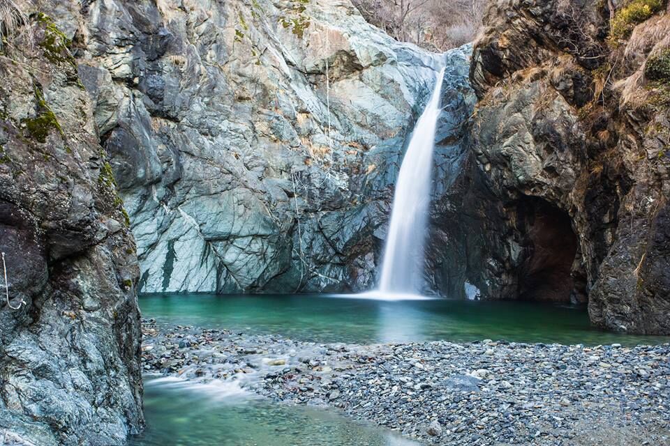
An appreciable panoramic point over the area can be reached on the right, about 50 meters downstream from the waterfall, with a steep wooden fenced path.
From the Goja, continue for a short stretch of ascent on the path and head towards borgata Giorda. From here, turn left and continue on the road. At the fork, turn right and reach the Chapel of the Madonna of the Snow, in borgata Bertolo.
Then descend along the road for a few hundred meters, then take trail no. 579 towards borgata Morando and return to the center of Almese.

Ano
Ano
The natural site of the Goja del Pis is accessible exclusively on foot through a path, and in the last section it is necessary to walk on stones and rocks made slippery by water. Appropriate clothing and footwear are therefore recommended, as well as light and portable equipment in a backpack so as to have free hands.
Like all torrent areas, the Goja is an area subject to sudden floods, especially during summer storms; therefore, maximum caution is advised.
The bottom of the lake that forms under the waterfall tends to fill with debris carried downstream during the floods of the Messa. Diving from the top of the cliff is extremely dangerous. Those who violate these instructions do so at their own risk and peril.
From the A32 Turin Bardonecchia motorway, exit at Avigliana Ovest and, at the roundabout, take the second exit following signs for Almese along via Avigliana. At the roundabout, take the second exit remaining on via Avigliana for about 1 km. Turn right into Piazza Martiri della Libertà, then right again into Piazza della Fiera.
Park the car in Piazza della Fiera.
T2
Oblíbené prohlídky v okolí
-
4.7
On the summit of the magical Musiné
světloTuristika 6.94 km -
Avigliana Lakes - Easy route, ideal for families with children
světloTuristika 9.25 km -
CASELETTE - Monte Musiné
středníTuristika 7.52 km -
VALLO TORINESE Passo della Croce and the Turu
středníTuristika 4.29 km -
COLLE DEL LYS Partisan Trail
středníTuristika 11.6 km -
GIVOLETTO Madonna della Neve on Monte Lera
středníTuristika 6.11 km -
5.0
Unspoiled woods and ancient hamlets in Valsangone - Selvaggio Loop - Bagaggera
světloTuristika 9.08 km -
VARISELLA The ruins of the Baratonia castle, churches, and pools of Varisella
středníTuristika 10.1 km -
Easy route - Monte Cuneo (Moncuni) Loop route from Reano
světloTuristika 7.97 km -
COLLE DEL LYS Monte Arpone loop
světloTuristika 4.50 km
Pěší turistika a stopování


Nenechte si ujít nabídky a inspiraci pro vaši příští dovolenou
Vaše e-mailová adresa byl přidán do poštovního seznamu.