WHH Etappe 2: Göttingen - Herzberg
střední
Pořiďte si tuto prohlídku do mobilního telefonu
WHH Etappe 2: Göttingen - Herzberg
střední
Jízda na kole
76.95
km
Naskenujte QR kód a spusťte navigaci v aplikaci bergfex.

Pěší turistika a stopování


WHH Etappe 2: Göttingen - Herzberg
střední
Vzdálenost
76.95
km
Doba trvání
05:20
h
Ascent
470
hm
Hladina moře
147 -
306
m
Stažení skladby
WHH Etappe 2: Göttingen - Herzberg
střední
Jízda na kole
76.95
km
Vorbei am Bismarckhäuschen wird Göttingens Innenstadt verlassen, und parallel zur Leine führt die Route zum Wendebachstausee, der in den Sommermonaten zu einer Abkühlung einlädt.
Kurze Zeit später ist schon...
Popis
Vorbei am Bismarckhäuschen wird Göttingens Innenstadt verlassen, und parallel zur Leine führt die Route zum Wendebachstausee, der in den Sommermonaten zu einer Abkühlung einlädt.
Kurze Zeit später ist schon das mittelalterliche Duderstadt, die „Hauptstadt“ des Eichsfeldes, erreicht. Nach der Besichtigung der Stadt ist ein Abstecher zum ca. 4 km entfernten Grenzlandmuseum Eichsfeld sehr empfehlenswert.
Zurück auf der eigentlichen Strecke folgt das Gut Herbigshagen mit dem Natur-Erlebniszentrum (Heinz Sielmann Stiftung).
Weiter geht es, mit einem steten Auf und Ab in Richtung Ruhmspringe. Die dort idyllisch in den Wald eingebettete Rhumequelle, eine der größten Karstquellen Europas, kündigt schon die Nähe des Harzes an.
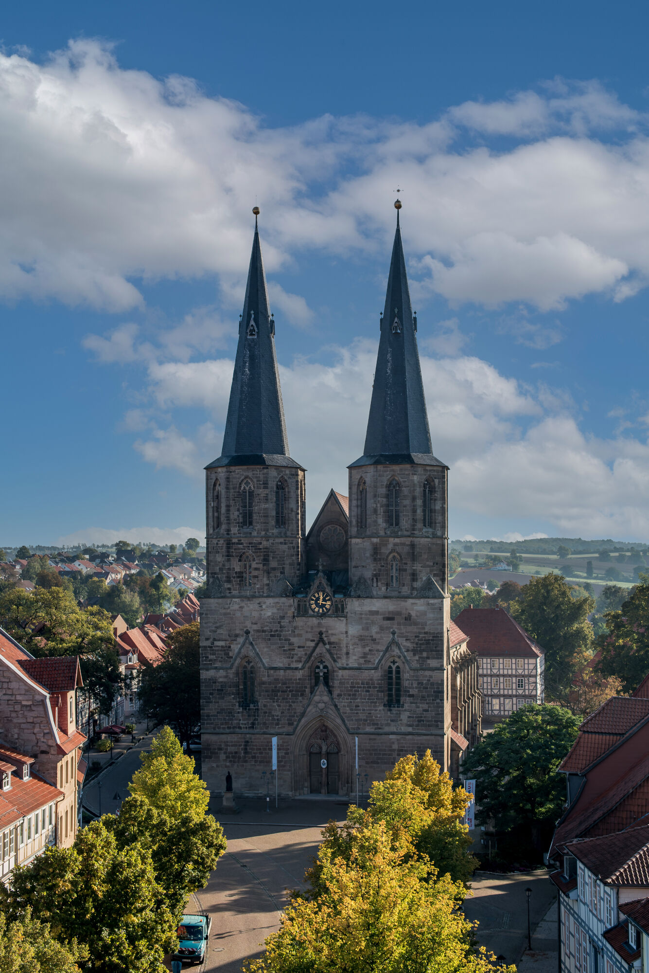
Von der Quelle sind es nur noch 10 km zum Etappenziel Herzberg mit seinem überragenden Welfenschloss und der sehenswerten Innenstadt.
Kurze Zeit später ist schon das mittelalterliche Duderstadt, die „Hauptstadt“ des Eichsfeldes, erreicht. Nach der Besichtigung der Stadt ist ein Abstecher zum ca. 4 km entfernten Grenzlandmuseum Eichsfeld sehr empfehlenswert.
Zurück auf der eigentlichen Strecke folgt das Gut Herbigshagen mit dem Natur-Erlebniszentrum (Heinz Sielmann Stiftung).
Weiter geht es, mit einem steten Auf und Ab in Richtung Ruhmspringe. Die dort idyllisch in den Wald eingebettete Rhumequelle, eine der größten Karstquellen Europas, kündigt schon die Nähe des Harzes an.
Von der Quelle sind es nur noch 10 km zum Etappenziel Herzberg mit seinem überragenden Welfenschloss und der sehenswerten Innenstadt.
Trasa
St. Nikolai
(155 m)
Místo konání bohoslužeb
0.2 km
Reinhausen
(203 m)
Vesnice
13.3 km
Heilig-Kreuz-Kapelle
(223 m)
Místo konání bohoslužeb
24.5 km
St.-Servatius-Kirche
(183 m)
Místo konání bohoslužeb
39.1 km
St. Cyriakus Basilika
(188 m)
Místo konání bohoslužeb
47.3 km
Sankt Sebastian
(168 m)
Místo konání bohoslužeb
65.8 km
Juesberg
(247 m)
Summit
76.6 km
Trasa
WHH Etappe 2: Göttingen - Herzberg
střední
Jízda na kole
76.95
km
Göttingen
(155 m)
Město
0.0 km
Innenstadt
(159 m)
Sousedství
0.1 km
St. Nikolai
(155 m)
Místo konání bohoslužeb
0.2 km
Hospital-Galerie
(154 m)
Sousedství
0.3 km
Rosdorf
(163 m)
Město
4.3 km
Niedernjesa Kirche
(169 m)
Piknikový stůl
8.6 km
Niedernjesa
(168 m)
Vesnice
8.6 km
Sankt Laurentius
(175 m)
Místo konání bohoslužeb
8.6 km
Reinhausen
(203 m)
Vesnice
13.3 km
Diemarden
(175 m)
Vesnice
15.1 km
Gasthaus Bieling "Zum Bahnhof Diemarden"
(177 m)
Restaurace
15.2 km
Alter Bahnhof Klein Lengden
(190 m)
Vypořádání
16.3 km
Zum Bahnhof
(192 m)
Restaurace
16.9 km
Steinsmühle
(189 m)
Vypořádání
18.0 km
Eichenkrug
(199 m)
Vypořádání
19.2 km
Wittmarshof
(193 m)
Vypořádání
19.3 km
Kapelle Wittmarshof
(213 m)
Místo konání bohoslužeb
19.3 km
Benniehausen
(203 m)
Vesnice
20.9 km
Helleberg
(225 m)
Vypořádání
21.9 km
Wöllmarshausen
(212 m)
Vesnice
23.6 km
Heilig-Kreuz-Kapelle
(223 m)
Místo konání bohoslužeb
24.5 km
Sankt Marien
(226 m)
Místo konání bohoslužeb
25.1 km
Rittmarshausen
(228 m)
Vesnice
25.2 km
Landgasthaus Rhode
(189 m)
Restaurace
31.4 km
Gasthaus Schenke
(189 m)
Restaurace
31.5 km
Nesselröden
(187 m)
Vesnice
31.8 km
Westerode
(172 m)
Vesnice
36.2 km
St.-Servatius-Kirche
(183 m)
Místo konání bohoslužeb
39.1 km
Duderstadt
(188 m)
Město
39.2 km
Steintor
(182 m)
Koridor/terén
39.6 km
Gerblingerode
(187 m)
Vesnice
41.4 km
Restaurant Hahletal
(198 m)
Restaurace
42.1 km
Gerblingerode
(187 m)
Vesnice
44.7 km
Steintor
(182 m)
Koridor/terén
46.8 km
Duderstadt
(188 m)
Město
47.2 km
St. Cyriakus Basilika
(188 m)
Místo konání bohoslužeb
47.3 km
Stadtberg
(240 m)
Hill
48.9 km
Fuhrbach
(219 m)
Vesnice
54.7 km
Hotel Zum Kronprinzen
(222 m)
Restaurace
54.8 km
St. Pankratius
(223 m)
Místo konání bohoslužeb
54.9 km
Brochthausen
(185 m)
Vesnice
58.1 km
Landgasthaus Zur Endstation
(178 m)
Restaurace
58.9 km
Ristorante Pizzeria Calabria
(161 m)
Restaurace
65.6 km
Rhumspringe
(163 m)
Vesnice
65.6 km
Sankt Sebastian
(168 m)
Místo konání bohoslužeb
65.8 km
Calabria
(158 m)
Restaurace
65.8 km
Rhumequelle
(165 m)
Zdroj:
67.1 km
Rhumasprung
(162 m)
Vypořádání
67.5 km
Pöhlde
(212 m)
Vesnice
70.2 km
Mooswiese
(241 m)
Sousedství
74.0 km
Herzberg (Harz)
(236 m)
Železniční stanice
74.5 km
St. Josef
(243 m)
Místo konání bohoslužeb
75.8 km
Nicolaikirche
(250 m)
Místo konání bohoslužeb
76.3 km
Juesberg
(247 m)
Summit
76.6 km
Grotte
(244 m)
Úhel pohledu
76.6 km
Herzberg
(240 m)
Město
76.9 km
Zatím žádné recenze
Oblíbené prohlídky v okolí
-
Reinhäuser Wald (Rundwanderung in der Gemeinde Gleichen durch den Reinhäuser Wald und das Wendebachtal)
Turistika 9.50 km -
Bike route from Göttingen around Die Gleichen
středníJízda na kole 43 km -
Weser-Harz-Heide long-distance cycle path from Hann. Münden to the Harz
heavyJízda na kole 131.3 km -
From Göttingen to Seeburger See and through the Weißwassertal
středníJízda na kole 53.9 km -
Bike round route from Lake Seeburg to Gieboldehausen
světloJízda na kole 29.5 km -
From Göttingen around Lake Seeburg
středníJízda na kole 64.6 km -
Five-church route in the northeast of Göttingen
středníJízda na kole 25.5 km -
Rundwandertour um Ebergötzen (Waldspaziergang durchs Weißwassertal)
Turistika 8.56 km -
Groß Lengden - Sonnenstein
heavyJízda na kole 69.5 km -
Health route through Untereichsfeld
středníJízda na kole 46.8 km
Pěší turistika a stopování

Více než 550.000 návrhů výletů, podrobné mapy a intuitivní plánovač tras dělají z aplikace nezbytnou výbavu pro všechny milovníky přírody.

Nenechte si ujít nabídky a inspiraci pro vaši příští dovolenou
Přihlaste se k odběru newsletteru
Chyba
Došlo k chybě. Zkuste to prosím znovu.
Děkujeme za vaši registraci
Vaše e-mailová adresa byl přidán do poštovního seznamu.
Zájezdy po celé Evropě
Rakousko
Švýcarsko
Německo
Itálie
Slovenia
Francie
Nizozemsko
Belgie
Polsko
Lichtenštejnsko
Česko
Slovensko
Španělsko
Chorvatsko
Bosna a Hercegovina
Lucembursko
Andorra
Portugal
Iceland
United Kingdom
Ireland
Greece
Albania
North Macedonia
Malta
Norway
Montenegro
Moldova
Kosovo
Hungary
San Marino
Romania
Estonia
Latvia
Belarus
Cyprus
Lithuania
Serbia
Bulgaria
Monaco
Denmark
Sweden
Finland