


The Pinerolese Apple Road
Úroveň obtížnosti: S0
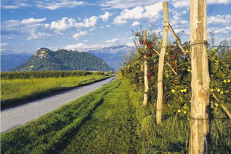
"The Pinerolese apple road" in its entirety is a circuit of roads that for about 150 km cross the fruit-growing territories of one of the most fertile and fascinating agricultural districts of our region,...
"The Pinerolese apple road" in its entirety is a circuit of roads that for about 150 km cross the fruit-growing territories of one of the most fertile and fascinating agricultural districts of our region, involving 14 Municipalities (Bibiana, Bricherasio, Campiglione Fenile, Cavour, Cumiana, Frossasco, Garzigliana, Luserna San Giovanni, Lusernetta, Macello, Osasco, Pinerolo, Prarostino, San Secondo) dedicated to fruit growing, which want to represent an attractive territory for local tourism and for the development of sustainable tourism. Naturalistic corners, artistic and historical monuments - ranging from the little jewel of the country chapel to the great Basilica, from the ruins of ancient castles, to the large manors and historic houses that can still be visited, museums, abbeys, historical itineraries - complete the cultural offer of the area: nature itineraries dominated by the Rocca di Cavour, which from its 162 meters high dominates the entire surrounding plain.

Desde Pinerolo se dirige hacia Baudenasca. Girando a la izquierda antes de la iglesia de la fracción, se llega a Macello. Desde aquí se continúa hacia Garzigliana. Desde el pueblo, se siguen las indicaciones para Cavour y, atravesada la SP 589, se gira a la derecha (indicaciones restaurante Cà del Buc) hacia la fracción Gemerello. Desde aquí se continúa hacia la fracción Babano y luego, siguiendo via Macello, se llega a Cavour. Desde aquí se avanza hacia Bibiana, girando a la derecha en Via Pellengo antes del pueblo. Llegados a Fenile y tomando Via S. Michele, se continúa hacia Bricherasio, girando a la izquierda en Via Giaire y avanzando hacia el puente del antiguo ferrocarril. En correspondencia con la Capilla Moreri, se gira a la izquierda y luego inmediatamente a la derecha. En el cruce con Via Godino Delio se toma a la izquierda para luego a la derecha en Via Pascoli. Se continúa por Via Airali Sup., luego por Via Biscaretti y Via Cardonata. Desde aquí se gira a la derecha y se continúa hacia Pinerolo.
Getting to Pinerolo is easy. For those arriving from Turin, take the A55 motorway and take the Pinerolo exit, following the signs for the city center.
Pinerolo can be reached by train from Turin
There are many paid and free parking lots in the center of Pinerolo.
S0
A vast network of restaurants, taverns, trattorias, farmhouses, B&Bs, hotels, holiday homes, ensures pleasant hospitality for all budgets.
Oblíbené prohlídky v okolí
-
PRAROSTINO From Piani to Sonagliette and back - SLOWLY TOGETHER
světloTuristika 6.60 km -
LUSERNA S.G. Upslowtour - Angrogna Valley Ring 11
středníJízda na kole 35.0 km -
VILLAR PELLICE Inverso path
světloTuristika 5.62 km -
TORRE PELLICE Hike to Bars d'la tajola (and Monte Castlus)
středníTuristika 4.40 km -
LUSERNA S.G. Upslowtour - Luserna Stone Loop 9
středníJízda na kole 38.1 km -
PINEROLO Trail "Ecomuseum of the Charcoal Piles"
středníTuristika 7.46 km -
PRAROSTINO Faro della Libertà Walk
světloTuristika 3.60 km -
ROLETTO Upslowtour - Ring 15 Pedemontano
heavyJízda na kole 29.8 km -
PINASCA Grandubbione Ring
středníJízda na kole 28.8 km -
BRICHERASIO Upslowtour - Loop 13 of the Ridges
středníJízda na kole 38.2 km

Pěší turistika a stopování


Nenechte si ujít nabídky a inspiraci pro vaši příští dovolenou
Vaše e-mailová adresa byl přidán do poštovního seznamu.