Lourdes Luz Ardiden Hautacam
heavy
Silniční kolo
Navigace na stránkách
Pořiďte si tuto prohlídku do mobilního telefonu
Mapa
Lourdes Luz Ardiden Hautacam
heavy
Silniční kolo
119.06 km
Naskenujte QR kód a spusťte navigaci v aplikaci bergfex.
QR Code
Pěší turistika a stopování

Lourdes Luz Ardiden Hautacam

Vzdálenost
119.06 km
Doba trvání
09:50 h
Ascent
2536 hm
Hladina moře
382 - 1710 m

Úroveň obtížnosti: 4

Stažení skladby
Mapa
Lourdes Luz Ardiden Hautacam
heavy
Silniční kolo
119.06 km

The loop from Lourdes to Luz Ardiden with a return via Hautacam is a truly epic and demanding outing, offering two legendary climbs in one route. This adventure is a real challenge that will test your...


Popis

The loop from Lourdes to Luz Ardiden with a return via Hautacam is a truly epic and demanding outing, offering two legendary climbs in one route. This adventure is a real challenge that will test your limits and require careful preparation.

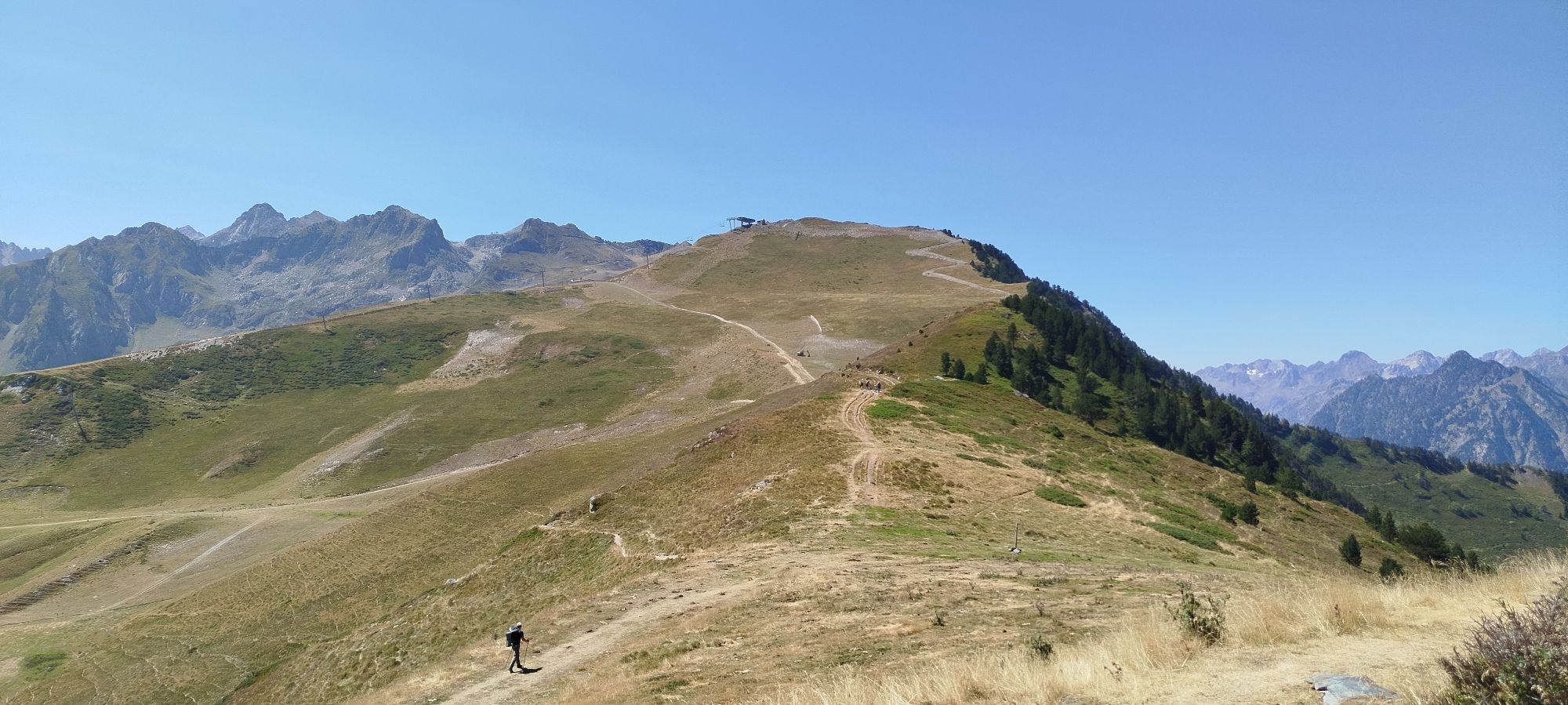
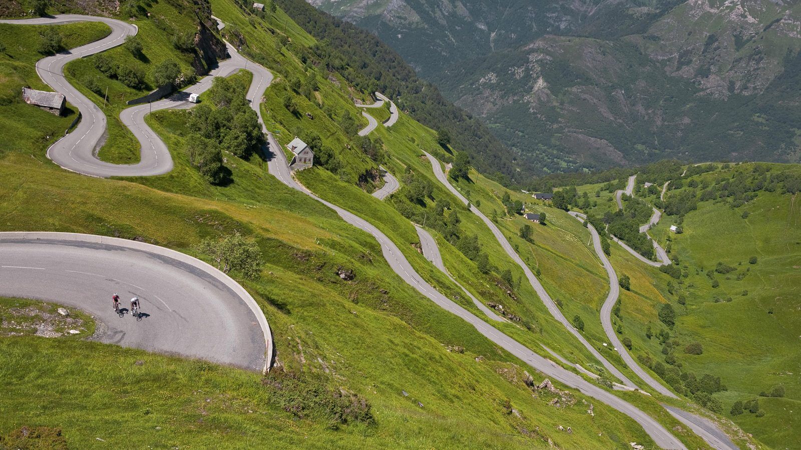
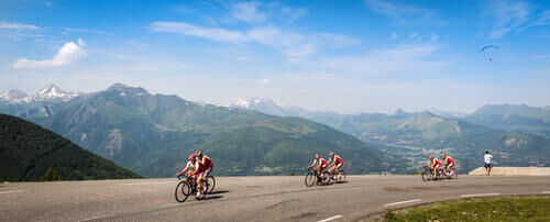
The first part of the ride takes you from Lourdes to the Luz gorges, then continues toward the legendary climb of Luz Ardiden, famous for its well-known hairpin bends. Once you have conquered this demanding climb, a well-deserved break awaits you to celebrate your arrival at the summit. The subsequent descent requires special attention to ensure safety.

After this descent, you will join the Argelès Valley and the foothills of Hautacam. The second climb of the day awaits you, perhaps shorter but certainly no less demanding, with rhythm variations throughout the ascent. Depending on the weather, be alert for grazing animals that might cross the road.

Trasa
Lourdes
(402 m)
Město
0.0 km
Église Saint-Joseph
(735 m)
Místo konání bohoslužeb
33.5 km
Saint-Sauveur
(715 m)
Vypořádání
33.7 km
Église Notre-Dame-de-l'Assomption
(661 m)
Místo konání bohoslužeb
62.0 km
Préchac
(445 m)
Vesnice
77.0 km
Saint-André
(930 m)
Vypořádání
84.8 km
Lourdes
(402 m)
Město
118.9 km
Trasa
Mapa
Lourdes Luz Ardiden Hautacam
heavy
Silniční kolo
119.06 km
Lourdes
(402 m)
Město
0.0 km
Aspin-en-Lavedan
(434 m)
Vesnice
1.9 km
Pont-Neuf
(387 m)
Koridor/terén
2.9 km
La Gare
(390 m)
Vypořádání
3.1 km
Lugagnan
(430 m)
Vesnice
3.4 km
Ger
(394 m)
Vesnice
4.3 km
Boô-Silhen
(407 m)
Vesnice
8.5 km
Argelès-Gazost
(446 m)
Vesnice
12.6 km
Église Saint-Laurent
(435 m)
Místo konání bohoslužeb
13.2 km
Lau-Balagnas
(434 m)
Vesnice
13.7 km
Saint-Savin
(542 m)
Vesnice
15.2 km
Adast
(443 m)
Vesnice
16.1 km
Pierrefitte-Nestalas
(483 m)
Vesnice
19.0 km
Soulom
(497 m)
Vesnice
19.1 km
Pont de la Reine Hortense
(601 m)
Koridor/terén
26.2 km
Chèze
(769 m)
Vesnice
26.5 km
Esquièze-Sère
(706 m)
Vesnice
30.1 km
Luz-Saint-Sauveur
(708 m)
Vesnice
30.5 km
Pont Napoléon
(703 m)
Úhel pohledu
33.1 km
Église Saint-Joseph
(735 m)
Místo konání bohoslužeb
33.5 km
Saint-Sauveur
(715 m)
Vypořádání
33.7 km
Bisens
(837 m)
Koridor/terén
36.4 km
Sazos
(840 m)
Vypořádání
37.0 km
Grust
(987 m)
Vypořádání
38.1 km
Cureille-Dessus
(1266 m)
Koridor/terén
41.3 km
Bayesse
(1441 m)
Koridor/terén
43.8 km
Bayesse
(1441 m)
Koridor/terén
50.9 km
Cureille-Dessus
(1266 m)
Koridor/terén
53.4 km
Grust
(987 m)
Vypořádání
56.6 km
Sazos
(840 m)
Vypořádání
57.8 km
Bisens
(837 m)
Koridor/terén
58.4 km
Houta
(671 m)
Koridor/terén
61.4 km
Sassis
(662 m)
Vypořádání
62.0 km
Église Notre-Dame-de-l'Assomption
(661 m)
Místo konání bohoslužeb
62.0 km
Chèze
(769 m)
Vesnice
65.2 km
Pont de la Reine Hortense
(601 m)
Koridor/terén
65.6 km
Beaucens
(486 m)
Vesnice
75.0 km
Lou Pé de las Vignas
(438 m)
Sousedství
76.7 km
Préchac
(445 m)
Vesnice
77.0 km
Couture-Bague
(438 m)
Vypořádání
78.1 km
Ayros-Arbouix
(485 m)
Vesnice
78.7 km
Ayros
(487 m)
Vypořádání
78.7 km
Arbouix
(562 m)
Vypořádání
79.8 km
Chez Marthe
(569 m)
Restaurace
79.9 km
Souin
(723 m)
Vypořádání
81.6 km
Café Restaurant Isaby
(794 m)
Restaurace
83.1 km
Artalens-Souin
(793 m)
Vesnice
83.1 km
Saint-André
(930 m)
Vypořádání
84.8 km
Saint-André
(930 m)
Vypořádání
101.1 km
Café Restaurant Isaby
(794 m)
Restaurace
102.8 km
Artalens-Souin
(793 m)
Vesnice
102.9 km
Souin
(723 m)
Vypořádání
104.4 km
Chez Marthe
(569 m)
Restaurace
106.0 km
Arbouix
(562 m)
Vypořádání
106.1 km
Ayros-Arbouix
(485 m)
Vesnice
107.2 km
Ayros
(487 m)
Vypořádání
107.2 km
Pouey-Pérous
(464 m)
Vypořádání
107.9 km
Boô-Silhen
(407 m)
Vesnice
110.0 km
Las Moures
(415 m)
Koridor/terén
112.3 km
Ger
(394 m)
Vesnice
114.1 km
Lugagnan
(430 m)
Vesnice
115.0 km
Hôtel des 3 Vallées
(392 m)
Restaurace
115.3 km
La Gare
(390 m)
Vypořádání
115.4 km
Pont-Neuf
(387 m)
Koridor/terén
116.1 km
Lourdes
(402 m)
Město
118.9 km
Informace o prohlídce

Epic bike route from Lourdes to Luz Ardiden finishing at Hautacam, in the Pyrenees. Challenge legendary mountain passes, breathtaking landscapes, guaranteed adrenaline!

Technologie
4 / 6
Stav
5 / 6
Krajina
6 / 6
Zkušenosti
5 / 6
Nejlepší roční období
Led
Úno
Bře
Dub
Kvě
Čen
Čec
Srp
Zář
Říj
Lis
Pro
Sdílet prohlídku
Mapa
Lourdes Luz Ardiden Hautacam
heavy
Silniční kolo
119.06 km
Chyba
Došlo k chybě. Zkuste to prosím znovu.
Informace o trase
Geologické zajímavosti

Ano

Prohlídka vrcholu

Ano

Vybavení

Before setting off:

Make sure the bike is in perfect mechanical condition, including tires and brakes Ensure the bike is well adjusted to your body shape Wearing a helmet is highly recommended Bring a repair kit Remember that traffic laws apply to cyclists at all times Never ride more than two abreast and move into a single file when traffic conditions require it Respect other users as you would like to be respected Choose a route adapted to your physical abilities Inform those close to you of your itinerary Check the weather conditions A first aid kit is not essential but can be very useful Find out and keep emergency contact numbers. Respect the environment by not throwing food wrappers on the roadside If you need to return at nightfall, make sure to see and be seen
Bezpečnostní pokyny

In case of emergency, dial 112

Informace o příjezdu
Příjezd

Consider carpooling

Veřejná doprava
Parkování

Parking near the departure point

Další informace a tipy
Úroveň obtížnosti

4

Další informace

For more information about our destination, visit our website

Tipy

This outing is a true cycling experience that requires excellent physical condition and proper preparation. You will be rewarded with stunning landscapes, epic climbs, and unparalleled personal satisfaction. In summary, it is a great and extensive ride that promises challenges and rewards for cyclists ready to take on the challenge.

Zatím žádné recenze
Napište recenzi

Recenze pomáhají ostatním uživatelům při výběru dalšího dobrodružství. Hodnoťte prosím pouze prohlídku, nikoli počasí nebo svačinu.

Výběrem jedné z hvězdiček ohodnotíte prohlídku
Špatné turné
Slabé turné
Průměrné turné
Dobrá prohlídka
Vynikající prohlídka
bergfex logo Získejte přehled Vždy živě na místě s více než 9 500 webkamerami. bergfex Jako uživatel Pro si nyní můžete zobrazit odpovídající webové kamery pro mnoho prohlídek v aplikaci prohlídky z. Můžete si tak přímo prohlédnout aktuální podmínky.
Pěší turistika a stopování

Pěší turistika a stopování

Pěší turistika a stopování
Více než 550.000 návrhů výletů, podrobné mapy a intuitivní plánovač tras dělají z aplikace nezbytnou výbavu pro všechny milovníky přírody.
Pěší turistika a stopování
bergfex bergfex