Espagnac - Chastang Dam
heavy
Jízda na kole
Navigace na stránkách
Pořiďte si tuto prohlídku do mobilního telefonu
Mapa
Espagnac - Chastang Dam
heavy
Jízda na kole
74.66 km
Naskenujte QR kód a spusťte navigaci v aplikaci bergfex.
QR Code
Pěší turistika a stopování

Espagnac - Chastang Dam

Vzdálenost
74.66 km
Doba trvání
07:30 h
Ascent
1243 hm
Hladina moře
236 - 659 m

Úroveň obtížnosti: 5

Stažení skladby
Mapa
Espagnac - Chastang Dam
heavy
Jízda na kole
74.66 km

The route starts from the small village of Espagnac, then follows the Doustre gorges, with superb views of La Roche-Basse.

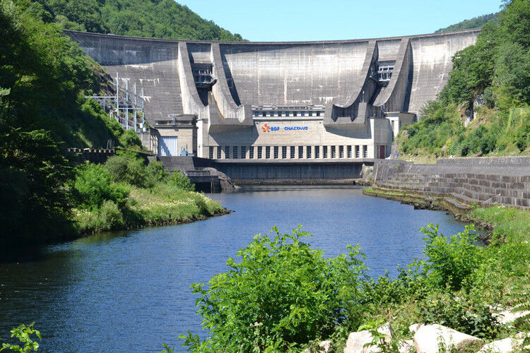
It then crosses the Dordogne at the Chastang Dam before climbing up to the village...


Popis

The route starts from the small village of Espagnac, then follows the Doustre gorges, with superb views of La Roche-Basse.

It then crosses the Dordogne at the Chastang Dam before climbing up to the village of Servières-le-Château (Servières Hill).

After a flatter section to Auriac, a fairly steep descent leads to the Chambon Bridge, a cast iron suspension bridge.*

A 5km climb (Charbonniers Hill) takes you back to the plateau before finishing more gently over the last 20 kilometres...

Trasa
Les Quatre Routes
(472 m)
Vypořádání
6.7 km
Église Saint-Étienne
(557 m)
Místo konání bohoslužeb
31.9 km
Darazac
(556 m)
Vesnice
32.0 km
La Chapeloune
(537 m)
Vypořádání
50.5 km
Église Saint-Barthélemy
(565 m)
Místo konání bohoslužeb
59.1 km
Les Plages
(541 m)
Vypořádání
60.2 km
Église Saint-Eutrope
(502 m)
Místo konání bohoslužeb
65.4 km
Trasa
Mapa
Espagnac - Chastang Dam
heavy
Jízda na kole
74.66 km
Les Quatre Routes
(472 m)
Vypořádání
6.7 km
La Roche Haute
(469 m)
Vypořádání
6.7 km
La Roche-Canillac
(433 m)
Vesnice
8.3 km
Le Moulin de Larchat
(306 m)
Vypořádání
8.8 km
La Roche Basse
(360 m)
Vypořádání
8.8 km
La Pierre Pose
(412 m)
Koridor/terén
11.6 km
La Farge
(494 m)
Vypořádání
12.8 km
Tra le Bos
(479 m)
Vypořádání
14.1 km
Croix de Farges
(503 m)
Vypořádání
14.2 km
Saint-Martin-la-Méanne
(494 m)
Vesnice
14.6 km
Église Saint-Martin-de-Tours
(486 m)
Místo konání bohoslužeb
14.9 km
Servières-le-Château
(479 m)
Vesnice
23.5 km
Église Saint-Étienne
(557 m)
Místo konání bohoslužeb
31.9 km
Darazac
(556 m)
Vesnice
32.0 km
Dezéjouls
(594 m)
Vypořádání
35.1 km
Les Jardins Sothys
(608 m)
Restaurace
39.1 km
Auriac
(606 m)
Vesnice
39.6 km
Labouldoire
(524 m)
Vypořádání
41.9 km
Le Relais des Pêcheurs
(276 m)
Restaurace
45.8 km
Laygue
(307 m)
Koridor/terén
46.7 km
La Chapeloune
(537 m)
Vypořádání
50.5 km
Beunac
(548 m)
Vypořádání
51.7 km
Le Massoubre
(557 m)
Vypořádání
52.0 km
La Vedrenne
(568 m)
Vypořádání
52.8 km
Le Peuch
(579 m)
Vypořádání
53.1 km
Saint-Merd-de-Lapleau
(586 m)
Vesnice
54.0 km
Église Saint-Médard
(565 m)
Místo konání bohoslužeb
54.2 km
La Goutte
(560 m)
Sousedství
54.5 km
Marcillac-la-Croisille
(564 m)
Vesnice
58.9 km
Église Saint-Barthélemy
(565 m)
Místo konání bohoslužeb
59.1 km
Pizzeria La Croisilla
(555 m)
Restaurace
59.3 km
Chez Marcel
(550 m)
Restaurace
59.4 km
Les Plages
(541 m)
Vypořádání
60.2 km
Jeux d'enfants
(492 m)
Dětské hřiště
61.4 km
Noger
(533 m)
Vypořádání
62.9 km
Plaziat
(545 m)
Vypořádání
63.4 km
Mas Bichier
(537 m)
Vypořádání
63.5 km
Église Saint-Eutrope
(502 m)
Místo konání bohoslužeb
65.4 km
Saint-Pardoux-la-Croisille
(516 m)
Vesnice
65.4 km
Le Feyt
(546 m)
Vypořádání
69.4 km
Les Chemineaux
(555 m)
Vypořádání
70.6 km
Le Mortier
(547 m)
Vypořádání
73.1 km
Le Coulin
(542 m)
Vypořádání
73.8 km
Informace o prohlídce

A very beautiful loop road cycling route, (very) hilly, that crosses a wild Dordogne valley several times, notably via the impressive Chastang dam.

Technologie
5 / 6
Stav
5 / 6
Krajina
5 / 6
Zkušenosti
5 / 6
Nejlepší roční období
Led
Úno
Bře
Dub
Kvě
Čen
Čec
Srp
Zář
Říj
Lis
Pro
Autor
Poskytuje Corrèze Tourisme
Prohlídku Espagnac - Chastang Dam zajišťuje outdooractive.com.
Logo
Sdílet prohlídku
Mapa
Espagnac - Chastang Dam
heavy
Jízda na kole
74.66 km
Chyba
Došlo k chybě. Zkuste to prosím znovu.
Vybavení

A well-maintained and well-equipped bike helps ensure your safety as well as that of other road users.

Before setting off:   

Make sure the bike is in perfect mechanical condition, including tires and brakes Ensure the bike fits your body properly Wearing a helmet is strongly recommended Bring a repair kit Remember that the Highway Code applies to cyclists at all times Never ride more than two abreast and move into a single file when traffic conditions require it Respect other road users as you would like to be respected Choose a route suitable for your physical abilities Inform those around you of your itinerary Check the weather conditions A first aid kit is not essential, but can be very useful Stay informed and keep emergency numbers handy Respect the environment by not littering food packaging on the roadside If you must return at dusk, make sure you can see and be seen
Bezpečnostní pokyny

Emergency number: 112

Informace o příjezdu
Parkování

Parking available in Espagnac.
Please respect traffic regulations.

Další informace a tipy
Úroveň obtížnosti

5

Další informace

Corrèze Tourism
Corrèze Tourism Development and Booking Agency
45 quai Aristide Briand
19000 TULLE
Tel: + 33 (0)5 55 29 98 78

Pěší turistika a stopování

Pěší turistika a stopování

Pěší turistika a stopování
Více než 550.000 návrhů výletů, podrobné mapy a intuitivní plánovač tras dělají z aplikace nezbytnou výbavu pro všechny milovníky přírody.
Pěší turistika a stopování
bergfex bergfex