







Reßeck

Like all destinations around the Staneralm, the Reßeck should not be underestimated despite its comparatively low summit height: The area is exposed to wind, and the summit slopes require secure conditions....
Like all destinations around the Staneralm, the Reßeck should not be underestimated despite its comparatively low summit height: The area is exposed to wind, and the summit slopes require secure conditions. When these conditions are met, you can experience magnificent, mostly solitary routes here!
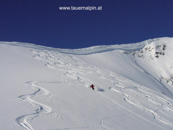

From Himmelbauer along the summer path to the Stanerhäuser and further to the Staneralm. Now basically follow the course of the Söbriacher Bach stream to the col between Reßeck and Törlkopf. Near the ridge to the summit.
Descent: Either the same as the ascent or directly from the summit to the northeast.
Secure conditions required!
Ano
Standard ski tour and avalanche transceiver equipment
After new snowfall, special attention must be paid to avalanche danger, especially in the area near the ridge.
From Obervellach via the B106, the Mölltal federal road, to Semslach. From there (signposted) on a single-track but usually well cleared mountain road to the Almgasthof Himmelbauer.
Directly at the Almgasthof Himmelbauer.
Respect your limits! 5 rules for responsible snowshoeing or ski touring:
Where available, stay on marked routes; always observe information boards as well as protected, conservation, and restricted areas. Show consideration for wildlife: avoid feeding areas and immediately and calmly retreat if you spot an animal. Avoid young tree stands (under three meters); ski edges can cause great damage to trees. Do not leave any waste behind. Avoid noise.Important for ski tours: Prohibition against skiing on young forests and reforestation areas
Webové kamery z prohlídky

Oblíbené prohlídky v okolí
-
4.5
Groppenstein Gorge Obervellach
středníTuristika 2.99 km -
5.0
Silberpfennig, Salzburger Land/Österreich
středníTuristika 13.8 km -
4.5
Mountain route from the Kötschachtal to the natural jewel Reedsee
středníTuristika 12.5 km -
4.8
Hohe Sonnblick Up
heavyTuristika 9.14 km -
4.9
Ankogelgruppe - Säuleck 3.086m - Detmolder Weg mit zu viel Schnee
heavyVysokohorská turistika 23 km -
4.8
Wanderung zur Schwussner Hütte
světloTuristika 8.07 km -
4.8
Rifflscharte - Kolmkarscharte - Bockhartscharte - Sportgastein
středníTuristika 13.5 km -
4.7
Bad Gastein Stubnerkogel-Zittrauer Tisch Rundwanderung
středníTuristika 18.6 km -
4.6
Hüttenkogel - Graukogel von der Bergstation
středníHorská turistika 4.68 km -
4.5
Ankogelbahn: mountain station - Kleine Tauernsee - middle station
středníTuristika 5.91 km
Pěší turistika a stopování


Nenechte si ujít nabídky a inspiraci pro vaši příští dovolenou
Vaše e-mailová adresa byl přidán do poštovního seznamu.





