


From Anzère to Lac de Tseuzier
The incline of the hike is not too steep, but the view along the path is absolutely worthwhile.
The path starts at the Anzère station; from here you can already overlook the Rhone Valley and admire the...
The incline of the hike is not too steep, but the view along the path is absolutely worthwhile.
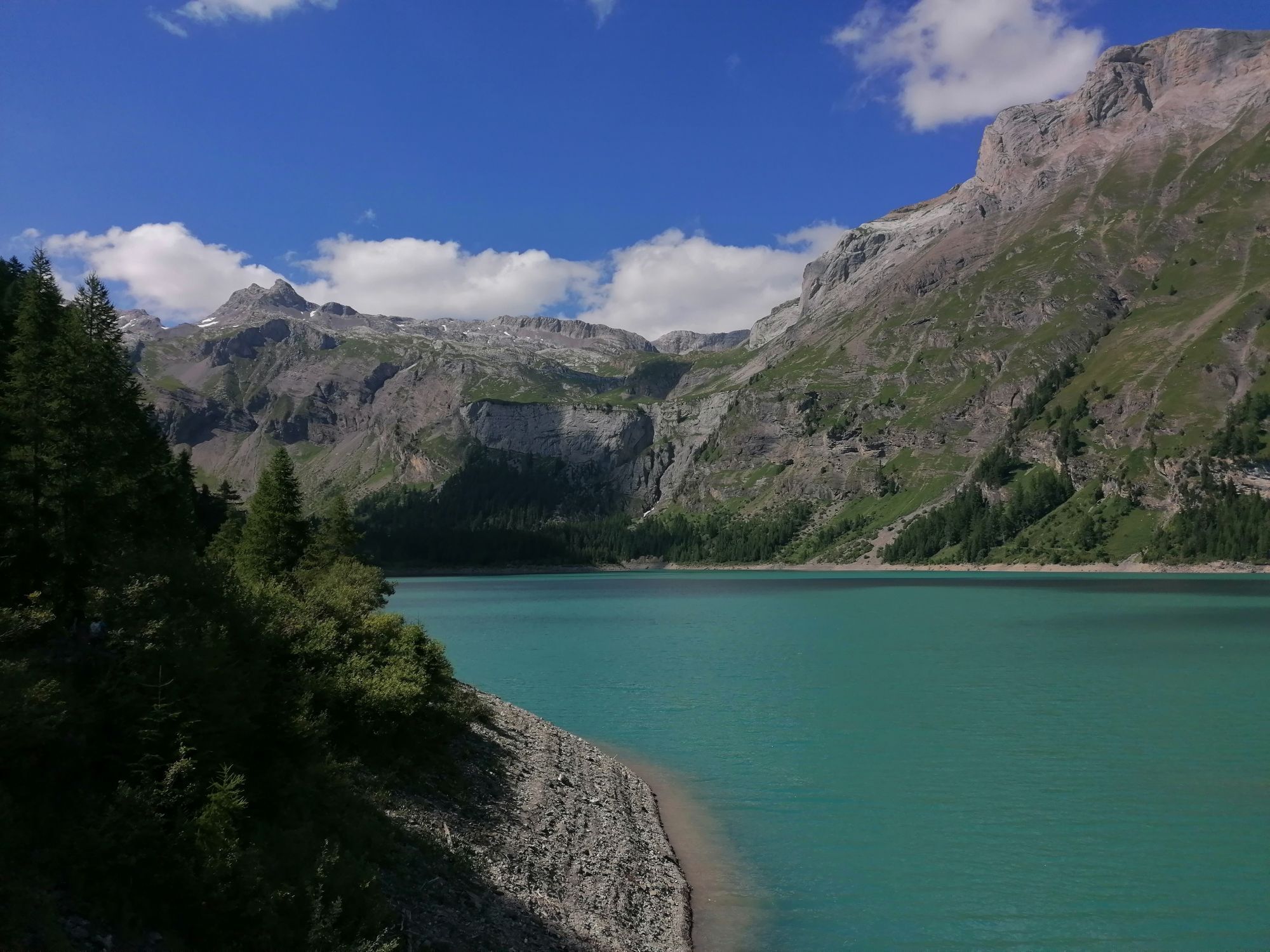
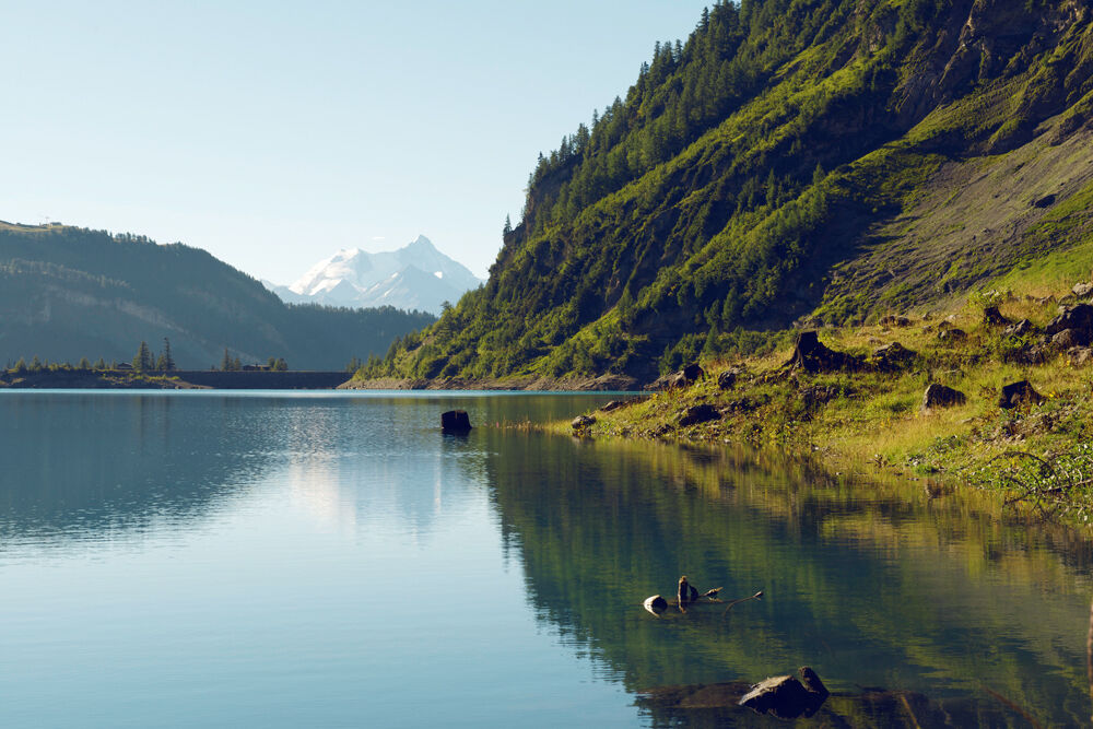
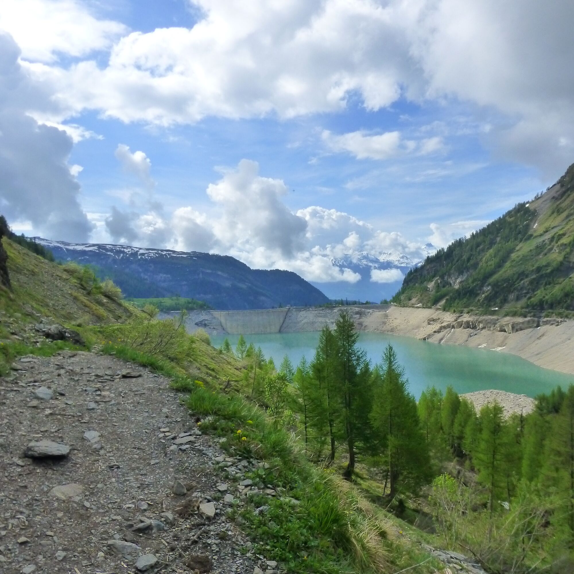
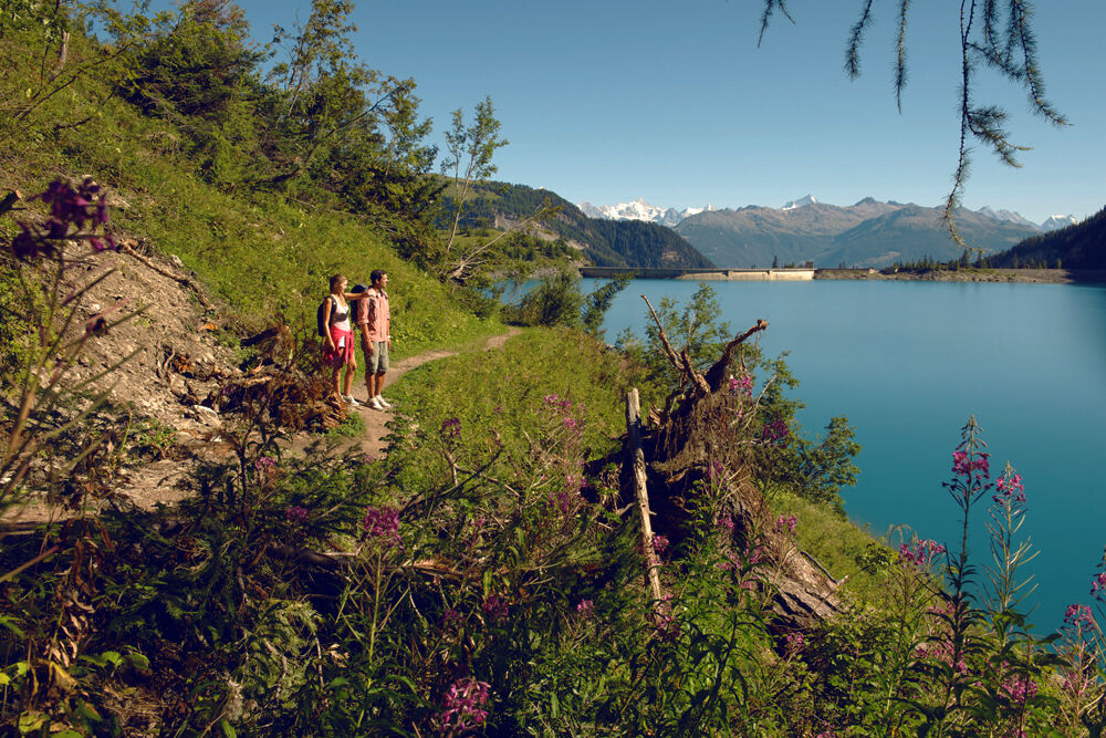
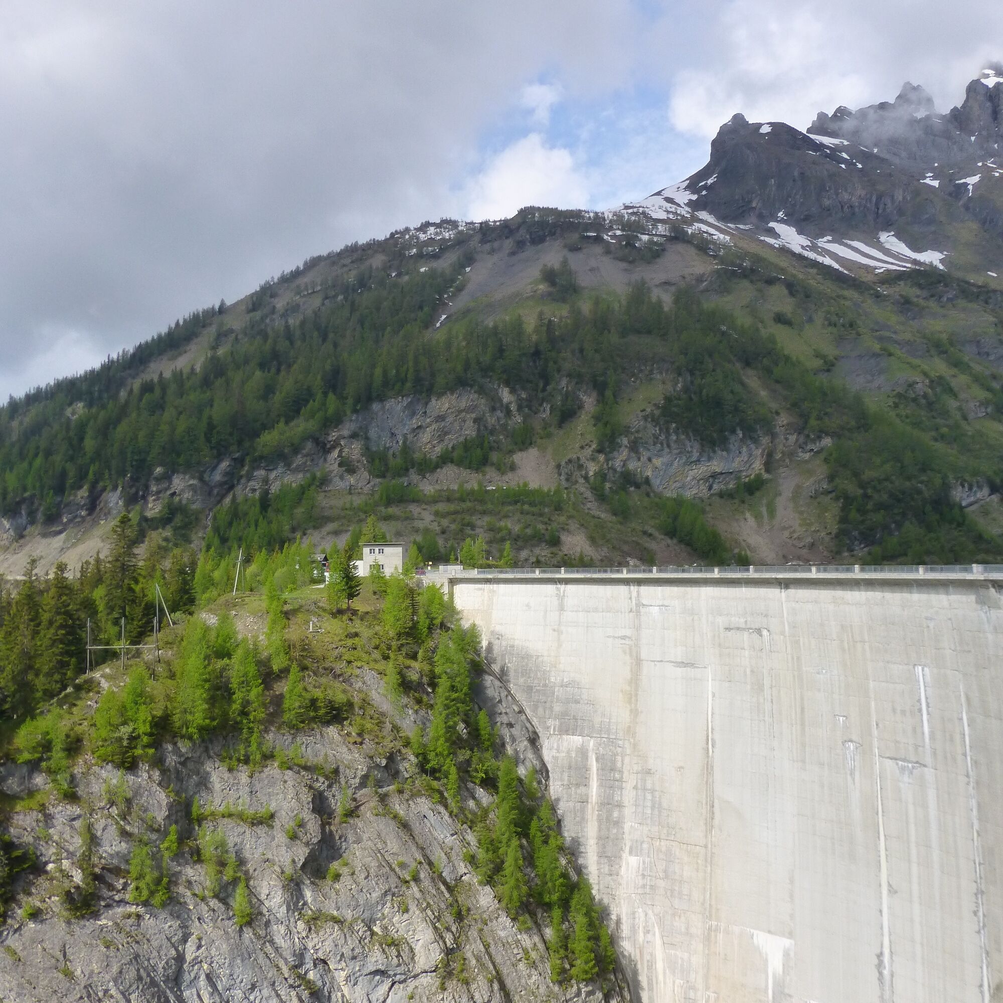
The path starts at the Anzère station; from here you can already overlook the Rhone Valley and admire the proud 4000-meter peaks on the other side. The higher you climb, the wilder, more wooded and rockier the valley becomes. Then the path leads to the Tseuzier Dam, which lies idyllically between the mountains.
The path follows the Suone of Sion, a typical irrigation canal built between 1901 and 1903. Some parts of the Suone are nowadays underground and not visible.
The hiking trail ends at the Tseuzier Dam, an artificial reservoir built between 1953 and 1957. It dams the water of the La Lienne river, which flows down from high above behind the dam.
Until the Middle Ages, this valley was used for Alpine crossings; people reached the Bernese Oberland via the Rawyl Pass at 2,425 m. Nowadays, no road leads over the pass, making it all the more popular for hiking.
Near the dam is the restaurant "Barrage de Zeuzier" (at 1,777 m above sea level) with a sun terrace. Ideal for a refreshment or a break.
This hike can be combined with the "Tour du Lac de Tseuzier."
Highlights of the hike:
Panorama hike with slight ascent Suone of Sion – historic irrigation canal Tseuzier Lake – idyllic mountain lake, restaurant with sun terrace
At the valley station of the gondola, the hiking trail leads with a pleasant incline to the northeast. For a long time, the path now follows the Suone of Sion, which initially runs underground and later continues to the north. The path continues to Les Rousses. The last part of the hiking trail runs along the road, through various tunnels up to the dam. Hikers can either walk through the tunnels or along the Suone. However, the path by the Suone is exposed and accessible via metal ladders. Only for hikers without fear of heights and not suitable for children or dogs.
The return route follows the same path. After the hike, you can return by post bus to the valley station of the mountain railways in Anzère (changing in St. Romain).
Ano
Ano
We recommend:
Good footwear Weather-dependent clothing: always carry a waterproof vest Headgear Sunscreen Water bottle Picnic Camera Binoculars (optional) Hiking poles (optional) Printout of the hiking trail (click "Print" to download)For certain hikes:
SwimsuitUse of hiking trails and information on this website is at your own risk. Conditions on site may cause route changes. Valais/Wallis Promotion assumes no responsibility for the accuracy and completeness of the information on this website. Assess your own skills and fitness well. Traveling the different routes is always at your own responsibility.
For all hikes:
Carry a map with you. Download the complete description of the hiking trail with a large-scale map by clicking "Print" at the top right of the page. Use only marked hiking trails and follow all signposts and instructions - for your own safety, to protect grazing animals, and in respect of wildlife. Close gates after passing through. Behave considerately towards other trail users, plants, and animals.For mountain hikes:
Carry additional sun protection. UV rays at high altitudes can be very strong, even in overcast weather. Plan your hike carefully: consider the required fitness level of all participants, weather forecasts, and seasonal dependencies. Weather conditions can change very quickly and without warning in the mountains. Appropriate clothing and sufficient provisions (food and drink) are very important. In unsettled weather, it is better to turn back early.For high alpine hikes:
Inform your family about your hiking route. If possible, avoid traveling alone. Do not venture onto glaciers without a mountain guide. Observe warning signs indicating dangers at riverbanks, along watercourses below dams and reservoirs: water levels can rise quickly and without warning.Motorway A9, exit 27 (Sion-Est), then follow the signs to Anzère.
Regular train connections to Sion, then by post bus to Anzère. Timetables for trains and post buses can be found at sbb.ch.
Parking available at the valley station of the mountain railways. Follow the local parking guidance system in Anzère.
More information about the destination can be found here:
AnzèreBe sure to stop in Botyre and visit the entertaining Suonen Museum; the 17th-century building is also absolutely worth seeing.
Oblíbené prohlídky v okolí
-
4.0
Grand Bisse de Lens
světloTuristika 8.73 km -
4.0
Tripon - Brac – Ancien Bisse du Torrent Neuf – St. Marguerite – Torrent Neuf – Prafirmin - St. Germain
světloTuristika 12.9 km -
4.0
Belvédère via ferrata
středníVia ferrata 1.81 km -
5.0
Wildstrubel Umrundung 4-Tage
středníTuristika 79.1 km -
Grand bisse d’Ayent
středníTuristika 11.7 km -
4.5
Sentier viticole / Wine trail
světloTuristika 7.49 km -
5.0
Tour des lapiaz de Zanfleuron
středníTuristika 9.64 km -
Bisse du Tsittoret
středníTuristika 10.6 km -
5.0
Wine route: Venthône – Leuk (Stage 4)
středníTuristika 12.8 km -
5.0
Mayentset Bike
středníMountainbike 21.6 km

Pěší turistika a stopování


Nenechte si ujít nabídky a inspiraci pro vaši příští dovolenou
Vaše e-mailová adresa byl přidán do poštovního seznamu.