


Sestriere - Borgata


From the village of Sestriere in the snowcat garage area, at the east end of the village, take the dirt road that descends along what in winter is uma ski slope.After a hundred meters you move completely...
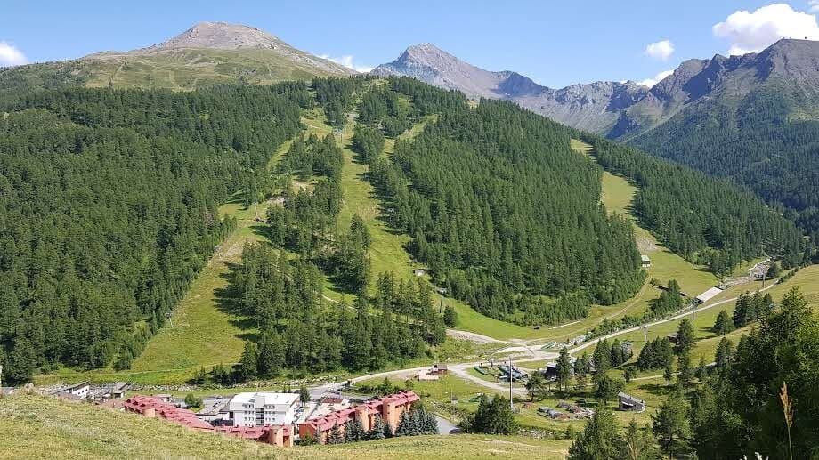
From the village of Sestriere in the snowcat garage area, at the east end of the village, take the dirt road that descends along what in winter is uma ski slope.After a hundred meters you move completely to the left descending and meet the path that runs along the south-facing slope of the wide valley and leads to Borgata Sestriere.
Easy itinerary in continuous slight descent that gives a wonderful view of Mount Rognosa and the Olympic slopes of the Banchetta area. Along the way you can see the bergeria, which in summer is populated by a large flock of sheep-not to be approached as they are protected by several Maremma shepherd dogs doing their "work."- Continue to the Borgata village among larch forests and lush grasslands.
Support and technical description by Simona Matheoud - Environmental hiking guide.

Wear clothing and footwear appropriate for the mountain environment
Evaluate route choice in advance through appropriate topographical maps;
Choose the routes to be hiked according to one's technical and physical abilities and available equipment;
Contact mountain guides and nature guides;
Consult weather reports and free APPs;
Do not undertake the hike alone or inform a trusted person of the route you intend to take.
Also remember that the walking times given for the various itineraries are average and indicative and may vary considerably depending on weather conditions and your abilities; the variability of environmental conditions may result in a significant decrease in the level of safety.
In case of marked danger it is not recommended to undertake any hike.
A32 Turin-Bardonecchia highway, exit Oulx, follow directions to Sestriere,
From Pinerolo, follow the Sp23R to Sestriere
Near the start of the route
Always carry water, snacks, sunscreen, sun hat, protective sunglasses, garbage bag, container for cigarette butts;
keep your distance, do not try to pet or approach herding dogs protecting the flocks;
do not disturb wildlife or pick flowers and plants;
keep your dog on a leash at all times;
do not throw garbage into the environment but take it with you, picking up any garbage left by others;
respect private property and marked areas.
Do not approach the sheep as they are protected by the Maremma sheepdogs
Oblíbené prohlídky v okolí
-
5.0
CESANA T.SE To Fenils (No. 48)
světloTuristika 4.29 km -
SESTRIERE Assietta Road
středníMountainbike 43.3 km -
The Roads of the Forts - stage 11 from Massello to Prali
heavyTuristika 13.7 km -
CESANA T.SE Val Thuras Valley
středníTuristika 7.58 km -
La Via dei Saraceni (Sauze d'Oulx)
středníMountainbike 33.6 km -
CESANA T.SE Thures - Cima Bosco
středníTuristika 10.6 km -
Sentiero Italia: Salbertrand - Bardonecchia
středníTuristika 19.5 km -
Val Thuras and Tornior bivacco (Cesana T.se)
středníMountainbike 37.5 km -
SAUZE DI CESANA Argentera Valley
středníMountainbike 30.7 km -
CESANA T.SE Ring Cesana - Sauze di Cesana
středníMountainbike 14.7 km
Pěší turistika a stopování


Nenechte si ujít nabídky a inspiraci pro vaši příští dovolenou
Vaše e-mailová adresa byl přidán do poštovního seznamu.