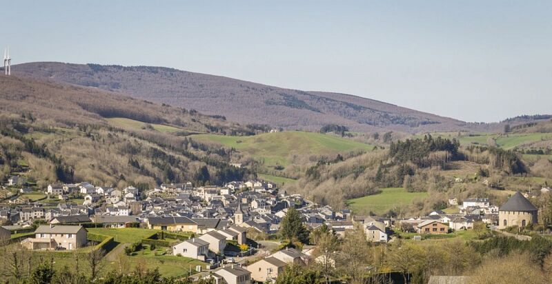
Le plo de Canac
heavy
Navigace na stránkách
Navigace na stránkách
Pořiďte si tuto prohlídku do mobilního telefonu
Le plo de Canac
heavy
Turistika
10.89
km
Naskenujte QR kód a spusťte navigaci v aplikaci bergfex.

Pěší turistika a stopování


Le plo de Canac
heavy
Vzdálenost
10.89
km
Doba trvání
04:00
h
Ascent
418
hm
Hladina moře
563 -
922
m
Stažení skladby
Le plo de Canac
heavy
Turistika
10.89
km
Enigmatic Statue-Menhirs...
Dating from the Neolithic period (- 2,500 years), intriguing statue-menhirs dot the eastern part of the Lacaune mountains. Shaped either by hammering with a hard stone pebble...
Popis
Enigmatic Statue-Menhirs...
Dating from the Neolithic period (- 2,500 years), intriguing statue-menhirs dot the eastern part of the Lacaune mountains. Shaped either by hammering with a hard stone pebble or by deep pecking to create a bas-relief carving, the best-preserved examples bear the social attributes of masculinity or femininity.
Along with menhirs and the painted or sculpted caves of the Upper Paleolithic (- 12,000 years), these statue-menhirs are among the rare artistic manifestations to have survived from such remote times. Studies of them have yet to provide definitive answers. Enigmatic and silent, they serve as a simple yet elegant reminder of the extent of our uncertainties.
Trasa
Canac
(572 m)
Vypořádání
0.1 km
Plo de Canac
(945 m)
Summit
9.1 km
Église Saint-Pierre de Canac
(556 m)
Místo konání bohoslužeb
10.6 km
Canac
(572 m)
Vypořádání
10.8 km
Trasa
Le plo de Canac
heavy
Turistika
10.89
km
Canac
(572 m)
Vypořádání
0.1 km
Plo de Canac
(945 m)
Summit
9.1 km
Église Saint-Pierre de Canac
(556 m)
Místo konání bohoslužeb
10.6 km
Canac
(572 m)
Vypořádání
10.8 km

Informace o trase
Trasa
Point 1: At the top of the village, take the path that starts between a house and the iron cross. It descends into the valley of the Espeyres stream. Cross the bridge and continue on the path to the right. Leave a path to the left. The path overlooks meadows before crossing the woods on the side. Continue on the track to the right then, at the next junction, take right again and climb the trail. Take the forest track on the right which descends to Pante.
Point 2: Climb the paved road leading to the Massié (! > viewpoint over the valleys!).
Point 3: Follow the D 169 to the right then the path to the right. It leads to Catonières.
Point 4: Go down into the hamlet and, before the stream, take left into the grass. The trail, lined with boxwood, crosses a small valley, then goes up to the left into the meadows. Cross the gate and continue on the wide path. Take the road to the right, leave the Lardenas farm on the right and continue on the rising road (spot at 885 m) opposite.
Point 5: On the descent, take the wide track to the right. Leave the track to the left and reach a new junction. > Off-trail: via the left track, access to the viewpoint of Plo de Canac.
Point 6: Continue on the main track. It skirts Plo de Canac on the west then makes a hairpin turn.
Point 7: Leave the trail towards the castle ruins. Follow the building on the left (possible to enter) before descending to rejoin the abandoned trail higher up (! > long and steep descent!).
Point 8: Continue the descent, then take the D 162 to the right to return to the starting point.
Vybavení
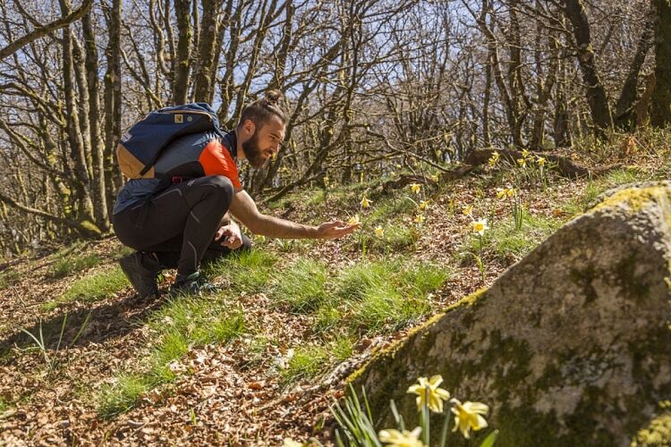
Clothing suitable for the season and conditions (cold, hot, humid…)
Hiking shoes adapted to the terrain (even for children!)
Hiking poles (useful for stability and to relieve joints)
Mobile phone and spare battery
Bezpečnostní pokyny
Before leaving:
Check the general and local weather, ensuring no precipitation Get information on the approach walk, altitude of the route, duration, possible escape routes (IGN map, GPS, guidebook, etc.) Assess possible risks by consulting mountain professionals, refuges, lodgings Inform a close person of your plan and contact them in case of changes: departure and return times, number of participants with each phone number, vehicle(s), parking Avoid going alone, use equipment suitable for the activity, adjusted and in good condition, headlamp, full first aid kit, survival blanket, etc.In case of problem, call 112 (European emergency number)
Informace o příjezdu
Parkování
Parking near the starting point
Další informace a tipy
Další informace
APIDAE Tourism data updated on 08/05/2022 by "Tarn Tourisme".
An error on this sheet? Write to the owner by referencing these details:
Sheet name: Le plo de Canac | Sheet ID: 789854 | URL (link) of this Outdooractive page.
An error on this sheet? Write to the owner by referencing these details:
Sheet name: Le plo de Canac | Sheet ID: 789854 | URL (link) of this Outdooractive page.
Zatím žádné recenze
Oblíbené prohlídky v okolí
-
3.0
CYCLE LOOP No. 29 - FROM THE VALLEYS TO THE PEAKS OF HAUT-LANGUEDOC
středníJízda na kole 64.3 km -
HIKING OF THE UPPER VALLEY OF THE MARE
středníTuristika 16.2 km -
HIKING OF THE ROQUANDOUIRE GATEWAY
středníTuristika 10.5 km -
VIALAIS HIKE
středníTuristika 13.4 km -
BANISSOUS HIKE
středníTuristika 9.69 km -
The Payrac discovery trail
světloTuristika 1.79 km -
Le Mont Barre
světloTuristika 6.21 km -
Cycle Route - C4 Around the Laouzas lake by bike
světloSilniční kolo 19.8 km -
From Laouzas to Montalet
heavyTuristika 15.4 km -
HAUTE VALLEE DE L'AGOUT HIKE
středníTuristika 17.0 km

Pěší turistika a stopování

Více než 550.000 návrhů výletů, podrobné mapy a intuitivní plánovač tras dělají z aplikace nezbytnou výbavu pro všechny milovníky přírody.

Nenechte si ujít nabídky a inspiraci pro vaši příští dovolenou
Přihlaste se k odběru newsletteru
Chyba
Došlo k chybě. Zkuste to prosím znovu.
Děkujeme za vaši registraci
Vaše e-mailová adresa byl přidán do poštovního seznamu.
Zájezdy po celé Evropě
Rakousko
Švýcarsko
Německo
Itálie
Slovenia
Francie
Nizozemsko
Belgie
Polsko
Lichtenštejnsko
Česko
Slovensko
Španělsko
Chorvatsko
Bosna a Hercegovina
Lucembursko
Andorra
Portugal
Iceland
United Kingdom
Ireland
Greece
Albania
North Macedonia
Malta
Norway
Montenegro
Moldova
Kosovo
Hungary
San Marino
Romania
Estonia
Latvia
Belarus
Cyprus
Lithuania
Serbia
Bulgaria
Monaco
Denmark
Sweden
Finland