Boucle d'Eyrignac
střední
Pořiďte si tuto prohlídku do mobilního telefonu
Boucle d'Eyrignac
střední
Mountainbike
13,89
km
Naskenujte QR kód a spusťte navigaci v aplikaci bergfex.

Pěší turistika a stopování


Boucle d'Eyrignac
střední
Vzdálenost
13,89
km
Doba trvání
01:31
h
Ascent
229
hm
Hladina moře
164 -
303
m
Stažení skladby
Boucle d'Eyrignac
střední
Mountainbike
13,89
km
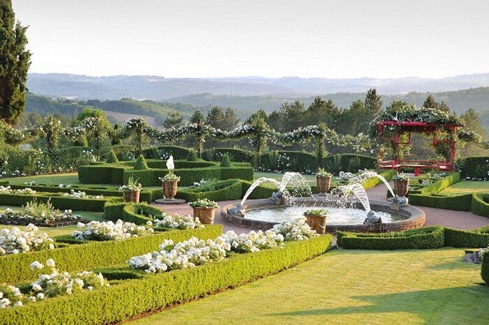
This loop will take you to the Eyrignac estate where beautiful views of the surrounding valleys await you. Don't hesitate to take time to visit the gardens of Eyrignac, superb French gardens open all year...
Popis
This loop will take you to the Eyrignac estate where beautiful views of the surrounding valleys await you. Don't hesitate to take time to visit the gardens of Eyrignac, superb French gardens open all year round. At the end of the walk, you will visit the village of Salignac.
Departure : from the sign located on the parking lot near the tourist office, take the main road towards Sarlat (D60), then, after 50 m, turn left towards " Simeyrols-Carlux " (D61). Continue straight on, then turn right towards the schools.
The topoguide containing the route of this hike is available for purchase in our tourist offices in Carlux and Salignac.
Trasa
Salignac-Eyvigues
(294 m)
Vesnice
0,1 km
La Croix de Ramade
(299 m)
Sousedství
0,1 km
Le Landre
(290 m)
Koridor/terén
11,3 km
Bois Bousquet
(292 m)
Koridor/terén
12,5 km
Le Barry
(251 m)
Sousedství
13,4 km
Salignac-Eyvigues
(294 m)
Vesnice
13,8 km
La Croix de Ramade
(299 m)
Sousedství
13,9 km
Trasa
Boucle d'Eyrignac
střední
Mountainbike
13,89
km
Le Duo
(299 m)
Restaurace
0,1 km
Salignac-Eyvigues
(294 m)
Vesnice
0,1 km
La Croix de Ramade
(299 m)
Sousedství
0,1 km
Pech Fourcou
(296 m)
Sousedství
0,5 km
Le Landre
(290 m)
Koridor/terén
11,3 km
Bois Bousquet
(292 m)
Koridor/terén
12,5 km
Le Barry
(251 m)
Sousedství
13,4 km
Salignac-Eyvigues
(294 m)
Vesnice
13,8 km
La Croix de Ramade
(299 m)
Sousedství
13,9 km

Informace o trase
Vhodné pro invalidní vozíky
Ano
Další informace a tipy
Další informace
OT du pays de Fénelon
Tipy
Zatím žádné recenze
Oblíbené prohlídky v okolí
Boucle La Salamandre
světloTuristika 5,57 kmBoucle de la Fontaine des Graves
středníTuristika 8,99 kmBoucle de Saint Quentin
středníTuristika 14,0 km- 5,0
Jardins et villages du Sarladais
heavyJízda na kole 53,1 km Boucle du Paluel
středníTuristika 10,3 kmGRP® du Pays de Fénelon
středníTuristika 174,6 kmChemin des meuniers - L'Inval
světloTuristika 7,65 kmCarlux en écomobilité - Plein les yeux à la gare Doisneau
světloJízda na kole 16,8 kmBoucle de la Turançonnaise n°14 / La Chapelle Aubareil
středníTuristika 9,42 kmBoucle de Carsac
světloJízda na koni 11,7 km

Pěší turistika a stopování

Více než 550.000 návrhů výletů, podrobné mapy a intuitivní plánovač tras dělají z aplikace nezbytnou výbavu pro všechny milovníky přírody.

Nenechte si ujít nabídky a inspiraci pro vaši příští dovolenou
Přihlaste se k odběru newsletteru
Chyba
Došlo k chybě. Zkuste to prosím znovu.Děkujeme za vaši registraci
Vaše e-mailová adresa byl přidán do poštovního seznamu.
Zájezdy po celé Evropě
Rakousko Švýcarsko Německo Itálie Slovenia Francie Nizozemsko Belgie Polsko Lichtenštejnsko Česko Slovensko Španělsko Chorvatsko Bosna a Hercegovina Lucembursko Andorra Portugal Iceland United Kingdom Ireland Greece Albania North Macedonia Malta Norway Montenegro Moldova Kosovo Hungary San Marino Romania Estonia Latvia Belarus Cyprus Lithuania Serbia Bulgaria Monaco Denmark Sweden Finland