







The Crapena

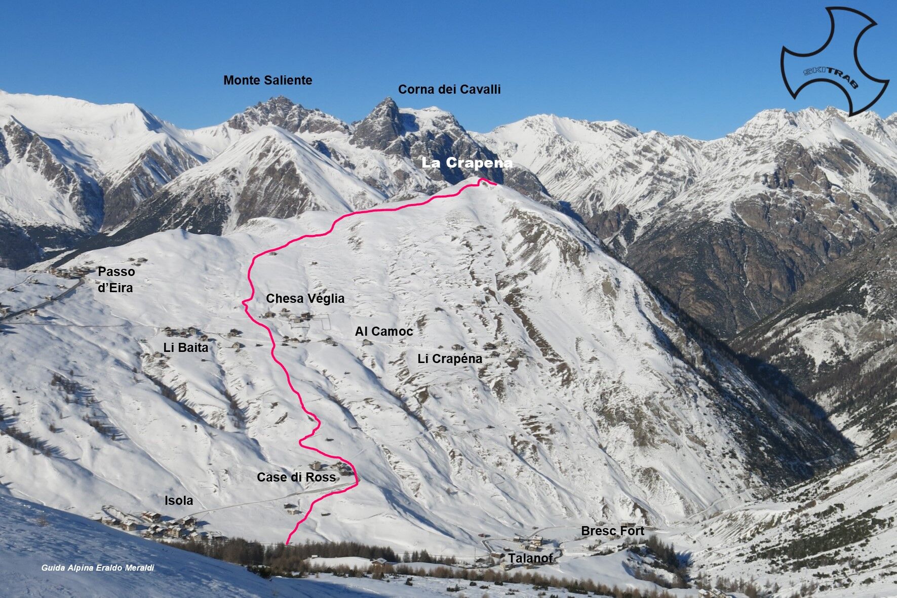
From Pila in a northwesterly direction, climb past the Ros huts and continue to the Chesa Veglia huts. Continue on the slope above following the wide ridge until you reach a flatter area. Now head north...
From Pila in a northwesterly direction, climb past the Ros huts and continue to the Chesa Veglia huts. Continue on the slope above following the wide ridge until you reach a flatter area. Now head north and over the last steep slope to reach the summit.

Tresenda, Grasso degli Agnelli, Monte del Buon Curato.
Self-rescue equipment (ARTVA, shovel and probe). Rampant.
The route description and trail are approximate and should be verified on site depending on the condition of the snowpack present during the hike.
Because this is a hike in a snowy mountain environment at high altitudes subject to continually changing snowpack conditions, it is advisable to have adequate experience in ski mountaineering, knowledge of the area, and up-to-date information on snow conditions.
Accompaniment with a professional guide is recommended.
The route description and trail are approximate and should be verified on site depending on the condition of the snowpack present during the hike.
Because this is a hike in a snowy mountain environment at high altitudes subject to continually changing snowpack conditions, it is advisable to have adequate experience in ski mountaineering, knowledge of the area, and up-to-date information on snow conditions.
Accompaniment with a professional guide is recommended.
Webové kamery z prohlídky
Monte Della Neve
Livigno - Mottolino
Mottolino - Bike Park
Livigno Ski School Area
Livigno
Livigno
Livigno Teola
Livigno - Hotel Primula
Livigno Ortszentrum
Livigno
SnowFarm
Centro Sci Fondo | Cross Country Stadium
Centro Sci Fondo | Cross Country Stadium
Centro Sci Fondo | Cross Country Stadium
Centro Sci Fondo | Cross Country Stadium
Centro Sci Fondo | Cross Country Stadium
Centro Sci Fondo | Cross Country Stadium
Scuola Sci Centrale

Oblíbené prohlídky v okolí
- 4.9
Circular hike Val Trupchun in the Swiss National Park
středníTuristika 13.8 km - 4.8
National Park: Grimmels (circular hike)
světloTuristika 6 km - 4.8
Val Nera Waterfalls
světloTuristika 5.70 km - 5.0
Crap da la Pare' with Joëlette
světloTuristika 4.58 km - 4.5
Muottas Muragl - Fuorcla Muragl - Val Chamuera
středníTuristika 17.6 km - 5.0
National park: Fuorcla Murter
středníTuristika 15.6 km - 4.8
Munt la Schera - Nationalpark
středníTuristika 13.1 km - 5.0
Monte Scale Loop Trail
heavyTuristika 7.53 km - 4.7
Süsom Givè - Il Jalet - Süsom Givè (long circular hike)
středníTuristika 8.68 km - 4.2
Val Federia Livigno
středníElektrokola 26.5 km
Pěší turistika a stopování


Nenechte si ujít nabídky a inspiraci pro vaši příští dovolenou
Vaše e-mailová adresa byl přidán do poštovního seznamu.





