







Tour to the Dreimärker



Difficulty level: moderate, not suitable for strollers.
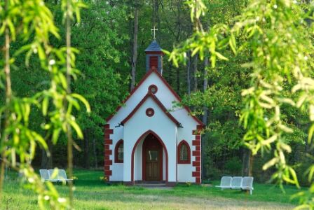
You begin the hike at the chapel on the gravel forest path with the symbol of the red butterfly initially heading towards Mönchberg. Shortly after the forest edge, the path branches off diagonally to the right, crosses Schmachtenberger Street and reaches the former Mechenharder debris site on the gravel path, where you turn left. After about 150 m, it goes left following the E3 symbol diagonally quite steeply up to the district boundary, which is clearly visible through old boundary stones. At the district boundary, it goes down almost to the Seltenbach, where you turn left and cross the stream bed. Afterwards, it goes diagonally up to the district road Klingenberg-Schmachtenberg and after crossing it, you reach the path marking “Dreimärker” through a beautiful deciduous forest stand. There is a shelter there, and you have the opportunity to use further well-marked hiking trails in various directions from there.
The nature park parking lot is located at the exit of Mechenhard towards Streit when coming from Erlenbach a. Main, immediately at the road intersection to Schmachtenberg and Streit.
Parking available
Oblíbené prohlídky v okolí
-
"Of Clay, Stones and Shards"
středníTuristika 8.31 km -
5.0
Dorfprozelten: Kollenburg-Chapel-Route
středníTuristika 11.8 km -
5.0
Roman Route in Miltenberg M1
heavyTuristika 15.3 km -
5.0
Rüdenau mountain hike R1
heavyTuristika 13.8 km -
Obernburg - Eisenbach round
středníTuristika 10.7 km -
MainRadweg Wertheim bis Miltenberg
Jízda na kole 35.7 km -
4.0
European cultural route: "From Hecke to Häcke in Hebboch"
středníTuristika 10.2 km -
Nibelungensteig - 6th stage from Miltenberg to Amorbach
heavyTuristika 13.2 km -
Miltenberg - Engelberg Monastery - Kleinheubach Castle - round trip
heavyTuristika 12.6 km -
3.0
Franconian Red Wine Hiking Route - 4th stage from Erlenbach to Klingenberg
světloTuristika 4.08 km
Pěší turistika a stopování


Nenechte si ujít nabídky a inspiraci pro vaši příští dovolenou
Vaše e-mailová adresa byl přidán do poštovního seznamu.





