







Short hiking trail in the Bürgstadt forest (No. 5)

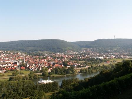
A river, a small stream, some lakes, vast forest areas, meadows, farmland, and vineyards. This is how nature presents itself around Bürgstadt, which is located at the confluence of the Erf and the Main...
A river, a small stream, some lakes, vast forest areas, meadows, farmland, and vineyards. This is how nature presents itself around Bürgstadt, which is located at the confluence of the Erf and the Main in the southwestern bend of the Main Triangle. The forested mountain ranges of the Odenwald on one side and the equally wooded heights of the Spessart on the other side of the Main harbor a network of nearly 60 kilometers of developed hiking trails. Several supraregional routes also run through the area. Thus, there are no limits to the direction and duration of excursions. It is an experience like no other, for example, hiking through lush green vineyard slopes in early autumn.


The starting point is the parking lot "Am Stutz." After a short climb, the path gently ascends the mountain towards Freudenberg via an old forest trail, always following marker 5 through the forest until it joins the Buschenweg and then returns to the starting point via the Gänsebrunnenweg. A relaxing forest trail without steep climbs, suitable for all ages.
Ano
Ano
sturdy hiking boots
A3 to Stockstadt exit, continue on B469 towards Miltenberg/ A3 to Marktheidenfeld exit, B469 continues towards Aschaffenburg via Miltenberg
By train from the direction of Aschaffenburg or Wertheim to the Miltenberg stop. Then take the bus to Bürgstadt at the station.
Parking lots at the Main

Oblíbené prohlídky v okolí
-
4.0
Amorbach Waldromantikweg aka. A9
středníTuristika 9.95 km -
"Of Clay, Stones and Shards"
středníTuristika 8.31 km -
5.0
Dorfprozelten: Kollenburg-Chapel-Route
středníTuristika 11.8 km -
5.0
Roman Route in Miltenberg M1
heavyTuristika 15.3 km -
MainRadweg Wertheim bis Miltenberg
Jízda na kole 35.7 km -
4.0
European cultural route: "From Hecke to Häcke in Hebboch"
středníTuristika 10.2 km -
5.0
Rüdenau mountain hike R1
heavyTuristika 13.8 km -
Nibelungensteig - 6th stage from Miltenberg to Amorbach
heavyTuristika 13.2 km -
Miltenberg - Engelberg Monastery - Kleinheubach Castle - round trip
heavyTuristika 12.6 km -
3.0
Franconian Red Wine Hiking Route - 4th stage from Erlenbach to Klingenberg
světloTuristika 4.08 km
Pěší turistika a stopování


Nenechte si ujít nabídky a inspiraci pro vaši příští dovolenou
Vaše e-mailová adresa byl přidán do poštovního seznamu.





