






The Himmelreich Jakobus Way for "EVERYONE"
The Himmelreich Jakobus Way (HJW) usually runs on hiking trails of the Black Forest Association (SWV).
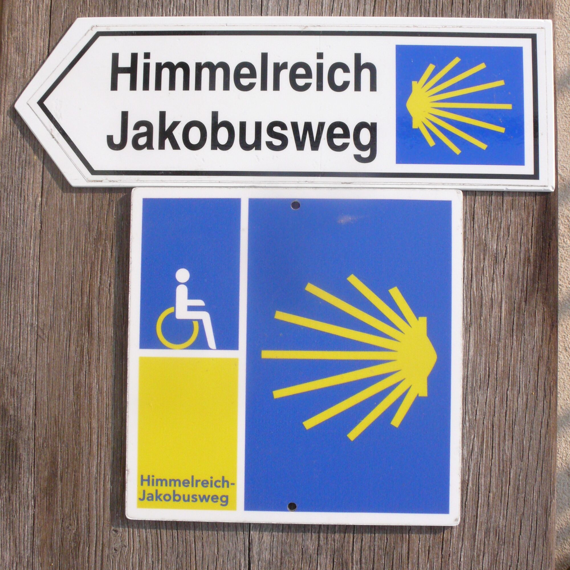
Deviations from this, e.g. for reasons of accessibility or topography, are specially marked with the...
Deviations from this, e.g. for reasons of accessibility or topography, are specially marked with the trail markers "shell and wheelchair".
The Jakobusweg is a demanding long-distance hiking trail that usually cannot be managed without companions. In particular, the descent from the Black Forest heights into the Rhine plain and further through the Breisgau with its vineyards in the Markgräflerland requires good physical condition.
Total length of the trail from Hüfingen via Freiburg to Weil am Rhein is approx. 170 km and is divided into three sections, with the corresponding number of daily stages between 8 and 13 km.
All stages have been tested with wheelchair users and "pushing" companions in the marking direction. Notes on this are given in the respective stages, as well as information about usable toilets and barrier-free inns.
Each stage is "linked" and available as a GPS track on the internet (www.himmelreich-jakobusweg.de).
No guarantee is given for the passability of the paths. Information about possible restrictions can be obtained from the tourist information centers and forestry or district offices.
Wheelchair users receive boarding and alighting assistance at all train stations if they register early with the Mobility Service of the Railway.
For further preparation, reference is made to the HJW companion book.
Contact addresses:
1) Association for the Promotion of the Himmelreich Jakobus Way e. V., www.himmelreich-jakobusweg.de
2) Contact phone for pilgrim accompaniment, Georg Körner, Tel. 07661/9077714
3) Taxi Scherer, Tel: 0771/2234
4) Taxi Vogt, also wheelchair transports (please register), Tel. 0771/5534
5) Mobility Service Railway, Tel. 01806512512
6) Hochschwarzwald Tourismus GmbH, Tel. 07652/1206 0


Ano
Report from the Badische Zeitung "Spirituality on the Way: Pilgrimage Routes in Southern Baden and the Black Forest"
Webové kamery z prohlídky
Feldberg - Falkau
Cafe Feldbergblick
Titisee - Hotel Brugger
Hinterzarten - Ferienhaus Carola
Hinterzarten - Adlerschanze
Hinterzarten - Adler-Skistadion
Breitnau - Eckerhof
Stollenbach
Titisee - Fewo Titiseeblick
Löffingen Alenberg
Göschweiler - Hohe Wacht
Göschweiler - Hohe Wacht
Göschweiler - Hohe Wacht
Dorf / Lenzkirch Saig Hochfirstweg
Alpen / Lenzkirch Saig Hochfirstweg
Získejte přehled Vždy živě na místě s více než 9 500 webkamerami. bergfex Jako uživatel Pro si nyní můžete zobrazit odpovídající webové kamery pro mnoho prohlídek v aplikaci prohlídky z. Můžete si tak přímo prohlédnout aktuální podmínky. Oblíbené prohlídky v okolí
- 4,8
Black Forest Highlands heritage trail - mills and saws in the gorge
středníTuristika 7,42 km - 3,7
Seerundweg Titisee
světloTuristika 5,84 km - 4,1
Höhenklimaweg Titisee-Rundweg
středníTuristika 7,44 km - 4,3
Through the mystical Bannwald forest to the Zweribach Waterfall
středníTuristika 12,3 km - 3,7
From Titisee to the Hochfirst with its stunning views
středníTuristika 10,6 km - 3,8
Premium Hiking Trail- Säbelthomaweg
středníTematická stezka 10,9 km - 4,0
Altitude on the Herzogenhorn
středníTuristika 11,1 km - 4,3
Mystical path to the Mathisleweiher pond
středníTuristika 8,94 km - 5,0
Premium Hiking Trail - Menzenschwander Geißenpfad
středníTematická stezka 10,3 km - 4,8
Sonnenaufgang und Feldbergsteig
středníTuristika 11,6 km
Pěší turistika a stopování


Nenechte si ujít nabídky a inspiraci pro vaši příští dovolenou
Vaše e-mailová adresa byl přidán do poštovního seznamu.





