


Gray Head


The trail starts from the frazioen Tschemenoal in Gressoney Saint Jean. The first part is quite steep with steps and goes through a forest of larch and fir trees until you reach the old Walser village...
The trail starts from the frazioen Tschemenoal in Gressoney Saint Jean. The first part is quite steep with steps and goes through a forest of larch and fir trees until you reach the old Walser village of Alpensu Grande cove there is a hut with rooms and kitchen. Continuing on you meet the alpine pastures of Montil Inferiore at 2001 meters and later those of Loasche at 2466 meters still used for the shelter of grazing beasts. Next comes Colle Pinter at 2777 meters where it is possible to descend into the nearby Val d'Ayas, turning right to climb a very steep section that leads to the Lateltin bivouac at 3132 meters equipped with about 20 beds. Continuing to the left we arrive at the crest of Mount Pinter, which with challenging passages even with the use of hands leads to the summit of Testa Grigia; the view here is fantastic and the eye can sweep over all the 4000 meters of the Aosta Valley.

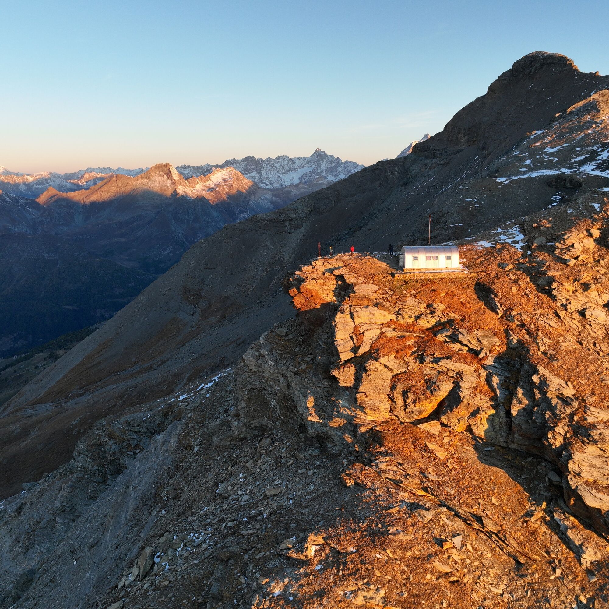
Set off, climbing up a steep path to Alpenzù 1779 m, pass between the houses and the fountain, which can serve as a water supply, then climb up on the left, following the signs to Pinter Col, passing shepherds' huts, such as those at Alpe Loache 2355 m. The final part of the trail to Pinter Col 2777 m becomes quite steep. From the pass, where you meet the climb coming from Val d'Ayas,, continue bending to the right, climbing the steep scree slopes and a gully, leading to the Lateltin bivouac 3120 m. From here cross a scree slope and reach the crest, initially scree and wide, until it becomes rocky. You pass directly over a short low wall that provides access to the ledge on the east slope. This is very wide and presents no major problems in the absence of snow. Covered entirely about 50 m in length, you reach a gully of rocks that you climb up, you will also find some fixed ropes that are not essential. With a few easy climbing steps (I/I+) you reach the small rocks that precede the comfortable and panoramic summit.
Ano
Ano
Ano
Hiking boots, snowshoes, backpack and raincoat.
Difficulty EEA hiking expert equipped.
Drive up the Gressoney valley along Regional Road 44, pass Gressoney Saint Jean and about 2 km, at Chemonal, stop at the service parking lot 1415 m of the Alpenzù Grande locality and the refuge of the same name.
Take the train from Milan or Turin and stop at Pont-Saint-Martin. Then continue by regular bus to Gressoney.
After passing Gressoney-Saint-Jean, you need to stop at Tschemenoal.
Service parking lot located at the trailhead.
Oblíbené prohlídky v okolí
- 4,8
Klein Matterhorn - P3824 - Breithorn Occidentale / Westgipfel
středníVysokohorská turistika5,53 km - 4,5
Quintino Sella al Felik 16 08 22
středníTuristika4,42 km - 5,0
Trail Running sulle 3 vette oltre i 3000m
heavyTrailrunning16,7 km - 5,0
Cime Bianche
středníHorská turistika18,9 km Monte Facciabella - Cresta SW - Ayas, Valle d'Aosta/Italia
středníZimní turistika7,68 km- 4,0
Monte Bieteron da Estoul
středníHorská turistika8,57 km - 5,0
Klein Matterhorn - Breithorn Occidentale / Westgipfel
světloVysokohorská turistika2,72 km Quintino Sella Refuge
heavyTuristika4,54 kmGnifetti hutte - pyramide vincent
světloTuristika4,08 km- 5,0
Mont Roisetta
středníTuristika12,6 km
Pěší turistika a stopování


Nenechte si ujít nabídky a inspiraci pro vaši příští dovolenou
Vaše e-mailová adresa byl přidán do poštovního seznamu.