- Stručný popis
-
Located in the heart of the Valais, the nature park Pfyn-Finges is nestled in a small area between the Rhone and its gravel islands, torrid steppes, dry pine forests, a floodplain forest with a tropical atmosphere, ponds and meadows.
- Obtížnost
-
střední
- Hodnocení
-
- Trasa
-
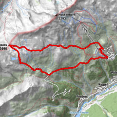
Siders (533 m)Église St. Catherine0,2 kmGlarey0,8 kmBuvette Milljeran5,1 kmSusten (630 m)11,3 kmLeuk (623 m)11,6 km
- Nejlepší sezóna
-
ledúnobředubkvěčenčecsrpzářříjlispro
- Nejvyšší bod
- 631 m
- Cílová destinace
-
Train station Leuk/Susten
- Výškový profil
-
 © outdooractive.com


-

-
AutorProhlídka Crossing the Pfyn Forest používá outdooractive.com na adrese ..
GPS Downloads


Obecné informace
Léčivé klima
Flora
Fauna
Další výlety v regionech
-
Oberwallis
1877
-
Leuk/Leukerbad
1033
-
Salgesch
284