Olsberg Gipfelkreuz - Du und ich- spiritueller Wanderweg der St. Nikolaus Kirche
Tematická stezka
Navigace na stránkách
Pořiďte si tuto prohlídku do mobilního telefonu
Mapa
Olsberg Gipfelkreuz - Du und ich- spiritueller Wanderweg der St. Nikolaus Kirche
Tematická stezka
8,00 km
Naskenujte QR kód a spusťte navigaci v aplikaci bergfex.
QR Code
Pěší turistika a stopování
Stáhnout pro iOS
Stáhnout pro Android

Olsberg Gipfelkreuz - Du und ich- spiritueller Wanderweg der St. Nikolaus Kirche

Vzdálenost
8,00 km
Doba trvání
02:56 h
Ascent
333 hm
Hladina moře
335 - 692 m
Stažení skladby
Mapa
Olsberg Gipfelkreuz - Du und ich- spiritueller Wanderweg der St. Nikolaus Kirche
Tematická stezka
8,00 km

@font-face {font-family:"Cambria Math"; panose-1:2 4 5 3 5 4 6 3 2 4; mso-font-charset:0; mso-generic-font-family:roman; mso-font-pitch:variable; mso-font-signature:-536869121 1107305727 33554432 0 415...


Popis
@font-face {font-family:"Cambria Math"; panose-1:2 4 5 3 5 4 6 3 2 4; mso-font-charset:0; mso-generic-font-family:roman; mso-font-pitch:variable; mso-font-signature:-536869121 1107305727 33554432 0 415 0;}@font-face {font-family:Aptos; mso-font-charset:0; mso-generic-font-family:swiss; mso-font-pitch:variable; mso-font-signature:536871559 3 0 0 415 0;}p.MsoNormal, li.MsoNormal, div.MsoNormal {mso-style-unhide:no; mso-style-qformat:yes; mso-style-parent:""; margin-top:0cm; margin-right:0cm; margin-bottom:8.0pt; margin-left:0cm; line-height:107%; mso-pagination:widow-orphan; font-size:11.0pt; font-family:"Aptos",sans-serif; mso-ascii-font-family:Aptos; mso-ascii-theme-font:minor-latin; mso-fareast-font-family:Aptos; mso-fareast-theme-font:minor-latin; mso-hansi-font-family:Aptos; mso-hansi-theme-font:minor-latin; mso-bidi-font-family:"Times New Roman"; mso-bidi-theme-font:minor-bidi; mso-font-kerning:1.0pt; mso-ligatures:standardcontextual; mso-fareast-language:EN-US;}.MsoChpDefault {mso-style-type:export-only; mso-default-props:yes; font-size:11.0pt; mso-ansi-font-size:11.0pt; mso-bidi-font-size:11.0pt; font-family:"Aptos",sans-serif; mso-ascii-font-family:Aptos; mso-ascii-theme-font:minor-latin; mso-fareast-font-family:Aptos; mso-fareast-theme-font:minor-latin; mso-hansi-font-family:Aptos; mso-hansi-theme-font:minor-latin; mso-bidi-font-family:"Times New Roman"; mso-bidi-theme-font:minor-bidi; mso-fareast-language:EN-US;}.MsoPapDefault {mso-style-type:export-only; margin-bottom:8.0pt; line-height:107%;}div.WordSection1 {page:WordSection1;}

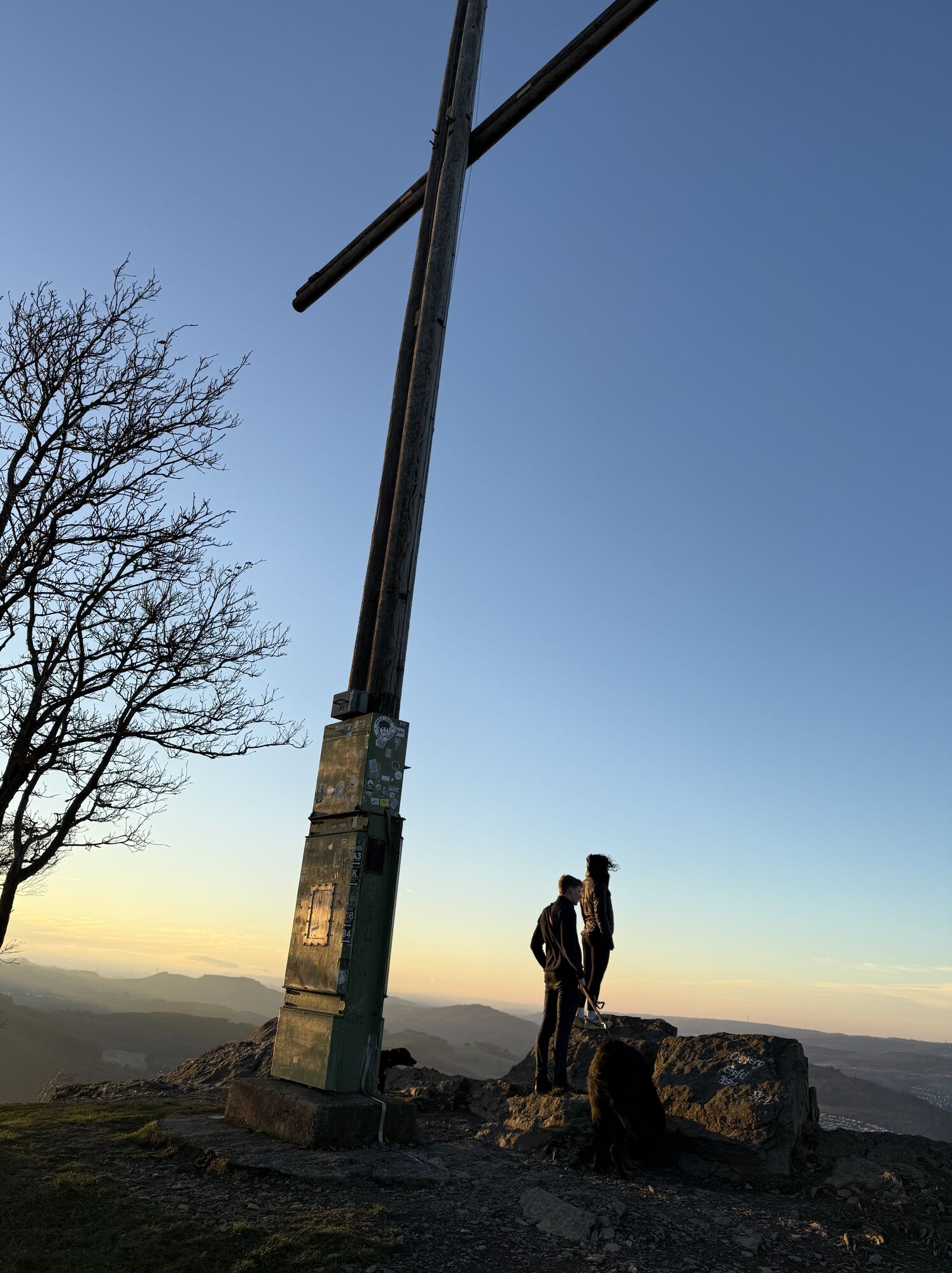
Olsberg Gipfelkreuz – Du und ich

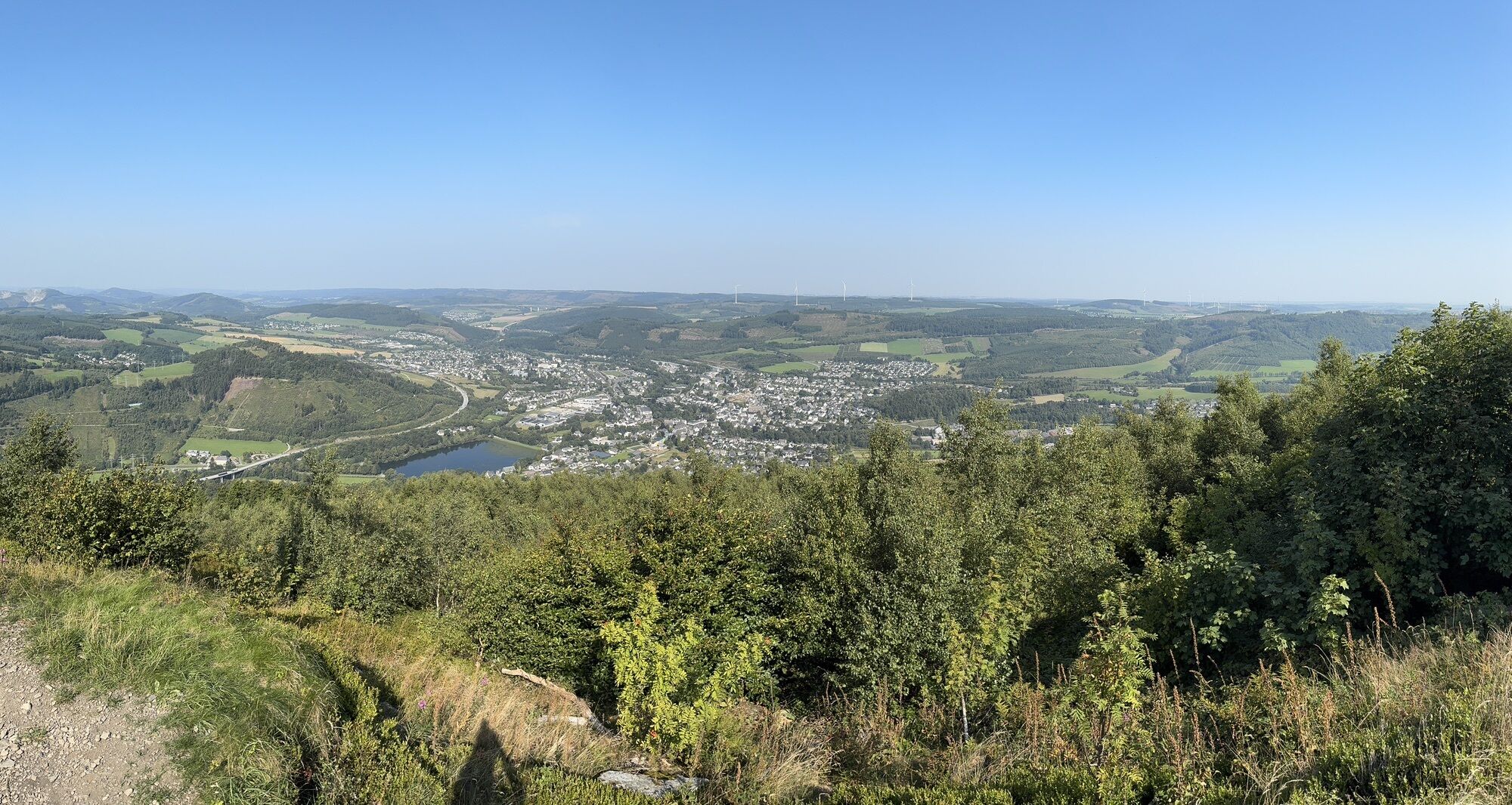
Sie verlassen St. Nikolaus am behindertengerechten Seiteneingang und gehen nach links an der Bahnhofstraße entlang bis zum 2ten Kreisverkehr. Dort abbiegen auf den Kurterrainweg 3 ,“Rutsche“ hoch, dann Am Olsberg folgen bis kurz vor die Hasleyhütte, dort am Wegkreuz dem Zeichen K (Kneippweg) folgen, vorbei an der Luisenquelle und über den steilen Klippenpfad zum Kreuz auf dem Olsberg mit weiten Ausblicken. der Kneippweg K führt Sie, am Waldaltar vorbei,  auf den Kurterrainweg 3, der Sie wieder nach Olsberg führt über die Bahnhofstraße nach St. Nikolaus.


Trasa
Sankt Nikolaus
(341 m)
Místo konání bohoslužeb
0,0 km
Olsberg
(360 m)
Vesnice
0,1 km
Olsberg
(704 m)
Summit
4,4 km
Waldaltar
(590 m)
Místo konání bohoslužeb
5,0 km
Trasa
Mapa
Olsberg Gipfelkreuz - Du und ich- spiritueller Wanderweg der St. Nikolaus Kirche
Tematická stezka
8,00 km
Sankt Nikolaus
(341 m)
Místo konání bohoslužeb
0,0 km
Olsberg
(360 m)
Vesnice
0,1 km
Luisenquelle
(575 m)
Zdroj:
3,4 km
Olsberg
(704 m)
Summit
4,4 km
Waldaltar
(590 m)
Místo konání bohoslužeb
5,0 km
Olsberg
(360 m)
Vesnice
7,9 km
Informace o prohlídce

@font-face{font-family:"Cambria Math";panose-1:2 4 5 3 5 4 6 3 2 4;mso-font-charset:0;mso-generic-font-family:roman;mso-font-pitch:variable;mso-font-signature:-536869121 1107305727 33554432 0 415 0;}@font-face{font-family:Aptos;mso-font-charset:0;mso-generic-font-family:swiss;mso-font-pitch:variable;mso-font-signature:536871559 3 0 0 415 0;}p.MsoNormal, li.MsoNormal, div.MsoNormal{mso-style-unhide:no;mso-style-qformat:yes;mso-style-parent:"";margin-top:0cm;margin-right:0cm;margin-bottom:8.0pt;margin-left:0cm;line-height:107%;mso-pagination:widow-orphan;font-size:11.0pt;font-family:"Aptos",sans-serif;mso-ascii-font-family:Aptos;mso-ascii-theme-font:minor-latin;mso-fareast-font-family:Aptos;mso-fareast-theme-font:minor-latin;mso-hansi-font-family:Aptos;mso-hansi-theme-font:minor-latin;mso-bidi-font-family:"Times New Roman";mso-bidi-theme-font:minor-bidi;mso-font-kerning:1.0pt;mso-ligatures:standardcontextual;mso-fareast-language:EN-US;}.MsoChpDefault{mso-style-type:export-only;mso-default-props:yes;font-size:11.0pt;mso-ansi-font-size:11.0pt;mso-bidi-font-size:11.0pt;font-family:"Aptos",sans-serif;mso-ascii-font-family:Aptos;mso-ascii-theme-font:minor-latin;mso-fareast-font-family:Aptos;mso-fareast-theme-font:minor-latin;mso-hansi-font-family:Aptos;mso-hansi-theme-font:minor-latin;mso-bidi-font-family:"Times New Roman";mso-bidi-theme-font:minor-bidi;mso-fareast-language:EN-US;}.MsoPapDefault{mso-style-type:export-only;margin-bottom:8.0pt;line-height:107%;}div.WordSection1{page:WordSection1;}OlsbergGipfelkreuz – Du und ich

Autor
Poskytuje Brilon Olsberg GmbH (Geschäftsstelle Brilon)
Sdílet prohlídku
Mapa
Olsberg Gipfelkreuz - Du und ich- spiritueller Wanderweg der St. Nikolaus Kirche
Tematická stezka
8,00 km
Chyba
Došlo k chybě. Zkuste to prosím znovu.
Zatím žádné recenze
Napište recenzi

Recenze pomáhají ostatním uživatelům při výběru dalšího dobrodružství. Hodnoťte prosím pouze prohlídku, nikoli počasí nebo svačinu.

Výběrem jedné z hvězdiček ohodnotíte prohlídku
Špatné turné
Slabé turné
Průměrné turné
Dobrá prohlídka
Vynikající prohlídka

Webové kamery z prohlídky

bergfex logoZískejte přehled Vždy živě na místě s více než 9 500 webkamerami. bergfex Jako uživatel Pro si nyní můžete zobrazit odpovídající webové kamery pro mnoho prohlídek v aplikaci prohlídky z. Můžete si tak přímo prohlédnout aktuální podmínky.
Pěší turistika a stopování

Pěší turistika a stopování

ke stažení pro iOSstáhnout pro Android
Pěší turistika a stopování
Více než 550.000 návrhů výletů, podrobné mapy a intuitivní plánovač tras dělají z aplikace nezbytnou výbavu pro všechny milovníky přírody.
Pěší turistika a stopování
bergfex bergfex